• RS MAY CLUB MEETING
    Hi Guest: Our monthly RS meeting on Wed. May 1st will be held at the Rooney Sports Complex. Details and directions are here. Early start time: 7:00 pm. to take advantage of daylight. We'll be talking ColoYota Expo and Cruise Moab.
    If you are eligible for club membership, please fill out an application in advance of the meeting and bring it with you.

Setting up APRS for Wheeling n' Stuff

DaveInDenver

Rising Sun Ham Guru
Joined
Jun 8, 2006
Messages
13,072
Location
Grand Junction
I got a chance to pull everything out and hook everything up, but not able see my location on aprs.fi.
I see other contacts in the log view, so I am able to receive .
When I Send Location, I do see the transmit light on the HT light red.
Also not able to send a message to my phone.
Map view makes APRSdroid stop responding.
IIRC, this is the point where I stopped messing with this last year.
There could be several issues here so pick them off individually.

About aprs.fi and your locations showing up. Several things have to work. Your TNC needs to key the radio and generate an audio signal that the radio modulates on the air. There needs to be enough power and signal strength to find a digipeater and ultimately an iGate. An iGate is a radio that listens for APRS packets and puts them on the APRS-IS (APRS-Internet Service).

One thing that a lot of people don't bother with is setting audio levels and timing. Being 1200 baud VHF APRS is generally very tolerant of poorly modulated signals. Rather than rehash, there's a couple of good (but technical) posts about this I'll refer you to.

https://owenduffy.net/blog/?p=2101
https://www.febo.com/packet/layer-one/transmit.html

You'll find your rate of successful positions on aprs.fi will go up if you are generating valid packets in the first place. The TNC2 doesn't have as much range to adjust as the TNC3 here but it has plenty. Every TNC/radio combination is going to be unique.

Once you get the hardware sorted then you have to be in range of a digipeater. Remember if you're using 5 watts with an HT you're going to be considerably lower power than the repeater likely is. So you need a good antenna, good aspect clear of obstacles (read: external antenna!), etc.

The repeater will have a good antenna and good location but it can't hear everything and is probably transmitting to you with 50 watts so it's probable that you'll hear it more often than it can hear you. This is especially true if you haven't dialed in your modulation. Noisy, distorted, mistimed packets are less likely to work unless RF path conditions are absolutely perfect.

Then assuming that you have all that stuff working you guys in busy places have to deal with lots of other stations. If two stations overlap a transmission different outcomes can occur. It may be a matter of stronger signal wins or it may be neither packet is heard. This is called a collision. It's anticipated in the protocol so a packet is constructed with redundancy and error correction that increases reliability with network traffic but it's still a question of probability. Since any particular digipeater can only handle one packet at a time and the overall network bouncing packets around can only handle so much bandwidth.

And the effect of collisions is proportional to the rate at which everyone is transmitting. If you and everyone in the area are beaconing every 30 seconds or on the minute the overall rate of success will be very low as measured by successful packets per hour, for example. So you and everyone have to play nice.

In this case moving your packets off the sync can help. Some software and TNC implement what's called time slotting. I don't think APRSdroid has this ability. I don't know about the TNC2 though it is an option in the TNC3 configuration under KISS options. What this does is adds a short delay or offset to your packet transmission, usually in hundreds of milliseconds or even full seconds specifically to reduce network congestion. TNCs are usually synchronized to GPS time and so they all know within a very small error the time precisely and so will usually start transmissions based on the top of the hour, minute or second. So if a dozen beacons all come at the top of every minute you get a dozen collisions trying to use 5 seconds and leaving 55 seconds quiet.

If you give tracker each an incrementing time slot of 5 seconds then instead of 12 competing for the same slot you have one trying every 5 seconds so that over the minute you only have one tracker competing at any slot and utilizing the whole minute. This also gives quiet periods for the digipeaters in between. It's the packet equivalent of leaving pauses when you talk over the air.

If implemented with some coordination you can fit hundreds of stations on the same frequency without a lot of collisions. But even done ad-hoc individually you only have to listen to know putting yourself on a 10 second time slot will give you relatively unused air time.

Also your path setting factors in the network capacity. If you ask your packet to be repeated a lot then it consumes bandwidth by a factor more. For example asking for a WIDE2-2 will cause your packet to bounce around 3 or 4 times and every digipeater within hundreds of miles will hear your packet and at least 2 of them will repeat and decrement. So being kind is important. When you're in the backcountry you might want 3 hops to get a packet to travel long distances. In town you only probably need one repeat and maybe asking for two to find an iGate, thus WIDE1-1, WIDE2-1 perhaps.

http://www.wa8lmf.net/DigiPaths/index.htm
http://www.aprs.org/fix14439.html
 
Last edited:

PabloCruise

Hard Core 4+
Joined
Aug 23, 2005
Messages
2,744
Location
Northern CO
Thanks for considering my challenges Dave. Your thoughts are informative as always!

I think the TNC is keying the radio successfully, I say that b/c when I Send Position in APRSdroid, the status light on the HT responds (goes momentarily to red).

Rookie question - but it seems difficult to find a basic legend of APRS symbols for some reason - Is a black diamond with D a digipeater? Or am I looking for the green star w/ an I? W0UPS is up behind Horsetooth. I know I can hit the HT repeater with this HT.

I hear you on properly setting up the TNC. I use the Mobilinked configuration app, and went through the set up instructions in the TNC2.2 user guide: http://www.mobilinkd.com/wp-content/files/MobilinkdTNC20c.pdf I was able to set the Receive volume, but I don't have anyone nearby to test the Transmit volume with. I did set Audio Output to Multiplex. I did see where they say the default volume setting level of 128 is often sufficient. They recommend setting output @ 2200Hz. The next time I used the configuration app and connected to the TNC, it was at 1200Hz. Not sure if that is significant?

I will look at the links you sent.

It makes sense that I can pick up the 50w repeater easier than getting out on 5w. Thanks for that. Is there anything additional I should check to make sure my modulation is properly set?

Understood on playing nice - I will check the KISS settings on APRSdroid.

I did set Connection Preferences for APRS digi path to Wide1-1,Wide2-1, so hopefully that is appropriate...
 

DaveInDenver

Rising Sun Ham Guru
Joined
Jun 8, 2006
Messages
13,072
Location
Grand Junction
Rookie question - but it seems difficult to find a basic legend of APRS symbols for some reason - Is a black diamond with D a digipeater? Or am I looking for the green star w/ an I? W0UPS is up behind Horsetooth. I know I can hit the HT repeater with this HT.
APRS symbols are not a rookie question, they're confusing.

The green star is typical of a digipeater, that's a standard symbol. Having a character in the middle tells you the symbol supports overlays and those will tell you additional functions the digipeater has. In this case a green star with an 'I' is a digipeater that also can serve as an iGate.

The black diamond symbol tells you it's an iGate. That means it only handles packets for the Internet but won't repeat packets on the air. Unless it specifies otherwise an iGate *should* be two-way, meaning it will both receive and transmit packets.

The way the APRS-IS works is when you announce your station on the air to an iGate it's supposed to then handle traffic both ways. That's important for messaging because when someone sends you a message only iGates that know you exist will transmit them. The alternative would be for all tens of thousands of iGate/radios to transmit the packet worldwide.

I'd have to research the length of time an iGate on the network remembers you, it's not indefinite. That's why some iGates are set to receive-only (green star with an 'R' usually). They only listen for packets and the direction is one-way. They won't respond to you and aren't useful for two-way messaging.

A black diamond with a 'D' overlay in the middle is a D-STAR digipeater with an Internet net, usually called a D-PRS iGate. I don't know for sure but I'm fairly certain they will act as a regular iGate for any packet. They do special functions for D-STAR radios, though.

http://www.aprs-is.net/DPRS.aspx

All of this is important when you dig into the network structure. It means you can't always have a reliable two-way connection. That's why packets have acknowledgements and are attempted multiple times, for example. For position it's pretty well covered but messaging gets complicated and especially unsolicited messages are often missed. You have to first tell the APRS-IS that you're available (e.g. 'In Service') and where you are for it to know how to route packets to you.

But a little secret, the ISS has an APRS iGate and digipeater so you can leverage that. It runs on a different frequency than the terrestrial network, though, so its not seamless.
 
Last edited:

DaveInDenver

Rising Sun Ham Guru
Joined
Jun 8, 2006
Messages
13,072
Location
Grand Junction
Nic (@Stuckinthe80s) asked a question about APRSdroid maps. It's a reoccurring question so perhaps consolidating a few things again.

APRSdroid - Option #1 (E-Z install)

https://aprsdroid.org

There are tons of versions of APRSdroid out there. The most typical version is found in the Google Play store and downloaded like any other app. This one should be the most current and capable with the widest range of devices and OS versions. It costs $5 which as I understand it more or less covers the cost of putting the app in the store.

https://play.google.com/store/apps/details?id=org.aprsdroid.app

Currently the released version should be 1.6.0a and dated August 29, 2020.

This version AFAIK only works with Google Maps online. The maps may be cached but I don't use this version to say for sure.

APRSdroid - Option #2 (Involved install)

https://aprsdroid.org/osm/

There is a version of APRSdroid built to use OpenStreetMaps (abbreviated OSM). This version was built to use the Mapsforge rendering engine.

To those not familiar, Mapsforge is a tool a developer can integrate into their app that takes care of dealing with vector maps. It does what Google Maps does - assembling tiles based on your location - but just completely offline.

This version is NOT available through the Play store

To get it you have to download and install an actual binary, which Google calls an "apk" file. Go to the "Offline Maps" tab on the APRSdroid website and it'll explain some of this. Suffice to say OSM only exists in purpose built versions.

IMPORTANT NOTE: The most current OSM apk is "APRSdroid-gl-2018-11-18_osm.apk". If you think you want to try OSM maps install this one first. If you install the 8/29/2020 version from the Play store it's not easy to go backwards with app versions in Android.

Using OSM maps

Once you get 2018-11-18_osm installed you need to supply a map. It won't look for one online, only locally.

One option is the all the U.S. in one map that KS9N compiled. There is a direct 3GB download but if you can try to use torrent instead (links for both options on the APRSdroid website).

The KS9N maps is fairly old being compiled in 2013. In the OSM world this is downright ancient so you might find a lot of missing information. But it gets you up and going.

Another option is OpenAndroidMaps.

https://www.openandromaps.org/en/downloads/usa_en

The hitch here is he's dropped support for the version of Mapsforge used in APRSdroid (which is v3) so you have to dig and find the archived version. If you download a v4 map it will not display in APRSdroid.

Screen Shot 2020-09-08 at 2.57.21 PM.png


By default APRSdroid will look for /sdcard/aprsdroid.map to display. However I set up my device with a "/sdcard/maps" folder containing several OpenAndroidMaps files that sites off the file system root. In APRSdroid preferences you can point directly to a map like I show below with any file name given the .map extension.

Screenshot_2019-12-09-08-52-44.png


Hopefully this works. The key is to get the 2018-11-18_osm for OSM and not from the Play store if you want completely offline maps.

I should mention that I think Android 10 won't load exceptionally old apps such as the OSM version. If you're on the bleeding edge Android OS you might have no choice but to use the Play version. I run Android 4.something on an unactivated phone.

Edit on 9/11/2023


I am currently running version 1.6.2b 2022-01-05 of the app. I don't have access to Google Play to I have to install apps directly and this is the latest apk that I'm aware of but those who do install it the regular way may have a newer version. So YMMV.

There is an additional step that I don't see here. It may be other places but should be here.

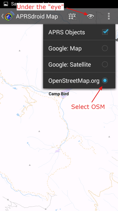
To run offline maps you need to check an additional box. Click the "eye" looking icon at the top of the screen and select openstreetmaps.org as your source and it'll look for the local file above. I don't know if it's looking for cached tiles and would go out to OSM and get news ones if there's no local file.

aprsdroid_addendum1.png
 
Last edited:

Stuckinthe80s

Rising Sun Member
Staff member
Joined
Dec 29, 2017
Messages
2,326
Location
Lakewood, CO
Nic (@Stuckinthe80s) asked a question about APRSdroid maps. It's a reoccurring question so perhaps consolidating a few things again.

APRSdroid - Option #1 (E-Z install)

https://aprsdroid.org

There are tons of versions of APRSdroid out there. The most typical version is found in the Google Play store and downloaded like any other app. This one should be the most current and capable with the widest range of devices and OS versions. It costs $5 which as I understand it more or less covers the cost of putting the app in the store.

https://play.google.com/store/apps/details?id=org.aprsdroid.app

Currently the released version should be 1.6.0a and dated August 29, 2020.

This version AFAIK only works with Google Maps online. The maps may be cached but I don't use this version to say for sure.

APRSdroid - Option #2 (Involved install)

https://aprsdroid.org/osm/

There is a version of APRSdroid built to use OpenStreetMaps (abbreviated OSM). This version was built to use the Mapsforge rendering engine.

To those not familiar, Mapsforge is a tool a developer can integrate into their app that takes care of dealing with vector maps. It does what Google Maps does - assembling tiles based on your location - but just completely offline.

This version is NOT available through the Play store

To get it you have to download and install an actual binary, which Google calls an "apk" file. Go to the "Offline Maps" tab on the APRSdroid website and it'll explain some of this. Suffice to say OSM only exists in purpose built versions.

IMPORTANT NOTE: The most current OSM apk is "APRSdroid-gl-2018-11-18_osm.apk". If you think you want to try OSM maps install this one first. If you install the 8/29/2020 version from the Play store it's not easy to go backwards with app versions in Android.

Using OSM maps

Once you get 2018-11-18_osm installed you need to supply a map. It won't look for one online, only locally.

One option is the all the U.S. in one map that KS9N compiled. There is a direct 3GB download but if you can try to use torrent instead (links for both options on the APRSdroid website).

The KS9N maps is fairly old being compiled in 2013. In the OSM world this is downright ancient so you might find a lot of missing information. But it gets you up and going.

Another option is OpenAndroidMaps.

https://www.openandromaps.org/en/downloads/usa_en

The hitch here is he's dropped support for the version of Mapsforge used in APRSdroid (which is v3) so you have to dig and find the archived version. If you download a v4 map it will not display in APRSdroid.

View attachment 88704

By default APRSdroid will look for /sdcard/aprsdroid.map to display. However I set up my device with a "/sdcard/maps" folder containing several OpenAndroidMaps files that sites off the file system root. In APRSdroid preferences you can point directly to a map like I show below with any file name given the .map extension.

View attachment 88705


Hopefully this works. The key is to get the 2018-11-18_osm for OSM and not from the Play store if you want completely offline maps.

I should mention that I think Android 10 won't load exceptionally old apps such as the OSM version. If you're on the bleeding edge Android OS you might have no choice but to use the Play version. I run Android 4.something on an unactivated phone.
Thanks Dave! (@DaveInDenver ) This helped a lot! The instructions on APRSdroid don't explain this as well as you just did. Maybe it's me? Maybe it's because I'm not an engineer. :hill:
 

rover67

Rising Sun Member
Joined
Nov 1, 2007
Messages
9,322
Location
Boulder, Co
I couldn't figure it out easily either. It took this whole thread and LOTS of back and forth from Dave. Too much back and forth really.s

One thing I will say is my tablet is real bad about auto updating APRS droid to the latest version, even if I tell it not to. So in order to maintain the map functionality of APRS Droid I basically keep the install executable file of the version mentioned in Daves post on my tablet in an easy to get to location and if I notice wonkeyness I reload the version of the software I want.
 

DaveInDenver

Rising Sun Ham Guru
Joined
Jun 8, 2006
Messages
13,072
Location
Grand Junction
Thanks Dave! (@DaveInDenver ) This helped a lot! The instructions on APRSdroid don't explain this as well as you just did. Maybe it's me? Maybe it's because I'm not an engineer. :hill:
I wish it was possible to edit posts. If you're up to speed enough to be installing APKs directly to your phone then you're probably technical enough to probably know most of what I implied, so it may be just preaching to a choir here.

But I neglected to say that if you download the KS9N map you have to rename the file to "APRSdroid.map" and move it to the root directory of the phone, e.g. /sdcard, for it to work with no further intervention.

There's a couple of ways to do this manipulation. The easiest is torrent or download on a PC, rename it and use a desktop applications like Android File Transfer to put it in place. Alternatively you can download it directly on your phone (if you like such a painful thing) and use a file manager on the phone to rename and move it.

If you go the OpenAndroidMaps (OAM) route you definitely will be doing some file system work to get files into place.

Also realize APRSdroid isn't the most intelligent mapping program so it doesn't do slippery maps. If the station you're trying to find on a map isn't located on the one you pointed to in the "Map File Name" preference it'll just be on a white background. You have to manually select a new map in preferences.

For all the ham dudes in the middle of the state this isn't likely to be a major problem but out here on the border I routinely get stations from Colorado, Utah, New Mexico and Arizona. The OAM divisions at least group Utah and Colorado so day-to-day it's not a super major headache.

Which reminds me, you can do custom maps from BBBike. One option being to build an OSM Mapsforge format.

https://extract.bbbike.org
 

Stuckinthe80s

Rising Sun Member
Staff member
Joined
Dec 29, 2017
Messages
2,326
Location
Lakewood, CO
I downloaded the V3 map that you pointed to in an earlier post, saved it to my SD card on my tablet and then told APRSdroid to reference that location. Although I never renamed it, the map loaded fine. However, I could only see myself but no other contacts. I also couldn’t see any other packets on the log sheet. (I guess that’s what it’s called). I went to APRS.fi and I could see myself there as well so it looks like I’m doing at least part of it right. I realize (I’m guessing) the map has nothing to do with whether or not I’m transmitting/receiving packet info, but it did load fine, visually, without having to rename the file.

That was about 10:00 last night and at that point I was pretty done. I’m sure it has something to do with how my settings are set in APRSdroid and/or how I have my tablet setup.
 

Stuckinthe80s

Rising Sun Member
Staff member
Joined
Dec 29, 2017
Messages
2,326
Location
Lakewood, CO
Also, torrent keeps getting referenced but there are about a dozen “torrent” named apps on the play store and I tried about 3 of them without any success. Which app are you guys using and what am I trying to accomplish with the app? Data conversion I’m guessing?
 

DaveInDenver

Rising Sun Ham Guru
Joined
Jun 8, 2006
Messages
13,072
Location
Grand Junction
I downloaded the V3 map that you pointed to in an earlier post, saved it to my SD card on my tablet and then told APRSdroid to reference that location. Although I never renamed it, the map loaded fine.
That is correct, if you go into preferences and point directly to a map there is no restriction to where you put the file or what it's named. The "/sdcard/aprsdroid.map" thing is only necessary if you do not manually select a map location or named .map file and rather rely on the app defaults.
However, I could only see myself but no other contacts. I also couldn’t see any other packets on the log sheet. (I guess that’s what it’s called). I went to APRS.fi and I could see myself there as well so it looks like I’m doing at least part of it right. I realize (I’m guessing) the map has nothing to do with whether or not I’m transmitting/receiving packet info, but it did load fine, visually, without having to rename the file.

That was about 10:00 last night and at that point I was pretty done. I’m sure it has something to do with how my settings are set in APRSdroid and/or how I have my tablet setup.
Did you set up the app to use a TNC and radio or did you connect to the APRS-IS with a valid passcode? Sounds to me like you haven't configured APRSdroid to correctly talk to anything or it's not in range of a digipeater or gateway if you're trying over the air. In Denver you should have pretty much constant packet traffic over the air but even out here in the sticks it only takes maybe 30 seconds or a minute for at least one station to show up.
 

Stuckinthe80s

Rising Sun Member
Staff member
Joined
Dec 29, 2017
Messages
2,326
Location
Lakewood, CO
So after spending the last two nights troubleshooting this, I think I'm finally up and running. The only thing I still can't figure out is how to type in WIDE1-1, WIDE2-1 in the digipath settings. It won't let me enter any more characters after typing WIDE1-1, as soon as I type in the comma, the field stops allowing entry.

At least I'm tracking now. Also, I'm surprised there aren't more HAMs on APRS in my area. The other night when I thought I wasn't receiving packets I think it is because there weren't any to receive in the area:
1599746076622.png


This is a snapshot from aprs.fi but I was able to see WA0GEH-10 on my tablet last night while driving around. So I guess I'm good?
 

Stuckinthe80s

Rising Sun Member
Staff member
Joined
Dec 29, 2017
Messages
2,326
Location
Lakewood, CO
@DaveInDenver can you post up some pics of your data radio setup? I know you've posted them on the forum before but I couldn't find them. I figured this is a good thread to capture the setup for future reference.
 

DaveInDenver

Rising Sun Ham Guru
Joined
Jun 8, 2006
Messages
13,072
Location
Grand Junction
There's plenty of stations around you. When you search on aprs.fi it builds a filter so only stations with your call sign are displayed. In the screen shot you posted it's just your station and the digipeaters and iGates that heard you. They insert their call sign when handling a packet.

Screen Shot 2020-09-10 at 8.35.36 AM.png


If you remove all filters you get this:

Screen Shot 2020-09-10 at 8.21.46 AM.png


And removing the weather (WX) stations (which are sometimes only on the Internet, not on the air) and just show APRS location (e.g mobile position stations), objects, repeaters and gates it's still a lot.

Screen Shot 2020-09-10 at 8.26.03 AM.png
 
Last edited:

Stuckinthe80s

Rising Sun Member
Staff member
Joined
Dec 29, 2017
Messages
2,326
Location
Lakewood, CO
There's plenty of stations around you. When you search on aprs.fi it builds a filter so only stations with your call sign are displayed. In the screen shot you posted it's just your station and the digipeaters and iGates that forwarded packets with your call sign.

If you remove all filters you get this:
View attachment 88884

And removing the weather (WX) stations (which are sometimes only on the Internet, not on the air) and just show APRS objects, repeaters and gates it's still a lot.

View attachment 88885
Well, Damn. And here I was thinking I was getting somewhere. When I was driving around last night and this morning, I turned my mobile unit on to 144.390 and I could hear the transmissions from my HT. I wasn't picking up on a lot of receiving though. ( I think ) I say this as I could hear the modem sound going off on a pretty regular basis and not much else.

So how can I see a base the base station, and one other mobile unit, KA0TTW-9, but nothing else?
 

AimCOTaco

Cruise Moab Committee
Staff member
Cruise Moab Committee
Joined
Aug 13, 2010
Messages
2,267
Location
Longmont, CO
You may need to tweak the receive audio levels... with mine I have to have the HT volume at the same setting each time to match the sensitivity setting in the 'linkd to get good packet receive sensitivity.
Sending is harder so with your send looking good, recieve should be easier to fix..
 
Top