I agree with all of the above in theory. I'm just struggling with if or how its working in the real world. Most of the "trails" on the list are on federal lands, maintained by the NFS or BLM. While I have not dug into it deeply, common sense tells me rarely does state money get given to federal agencies. So unless the state is funding an organization like Stay the Trail please tell me how my permit money goes to support the trails.
You are using an out of date browser. It may not display this or other websites correctly.
You should upgrade or use an alternative browser.
You should upgrade or use an alternative browser.
OHV permits required on full sized vehicles
- Thread starter treerootCO
- Start date
DomOfTheDead
Event Coordinator
I agree with all of the above in theory. I'm just struggling with if or how its working in the real world. Most of the "trails" on the list are on federal lands, maintained by the NFS or BLM. While I have not dug into it deeply, common sense tells me rarely does state money get given to federal agencies. So unless the state is funding an organization like Stay the Trail please tell me how my permit money goes to support the trails.
Funding, Donations, and Partnerships | Stay The Trail
do we know what percentage of the $25 goes to stay the trail?
Quick search yielded this info https://cpw.state.co.us/off-highway-vehicle-grants
Quick search yielded this info https://cpw.state.co.us/off-highway-vehicle-grants
DomOfTheDead
Event Coordinator
I do not know what percentage goes to STT but I do know that all of the funds generated from the OHV permits go directly back into the CO OHV program, as listed in this posted link. STT gets a majority of their funding from applying for a portion of this grant yearly. One of the factors that decide the size of the grant is recorded usage (log your trail hours!)do we know what percentage of the $25 goes to stay the trail?
Quick search yielded this info https://cpw.state.co.us/off-highway-vehicle-grants
nuclearlemon
Hard Core 4+
and as a reminder, you don't have to be on your adopted trail or on a club sponsored clean up run. if you clean up any trash on any trail, log those hours!!!One of the factors that decide the size of the grant is recorded usage (log your trail hours!)
I recently took an interest in looking into this again, and things are getting more confusing for me. There are four reference points that do not agree with each other:
-On-site signage
-MVUM
-Motorized Travel Management Analysis
-Stay the Trail website
Example: China Wall
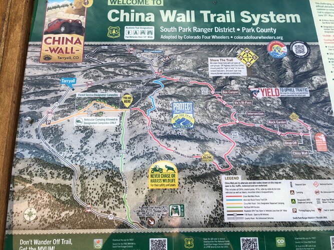
-On-site signage clearly indicates that it is an OHV Trail System. IMO this sign is really confusing.

-There is a sticker that says “Available Trail Designations For Vehicles Over 50” Wide” but the images show motorcycles, ATVs, SxS, and full-width. What is this sticker even trying to say?
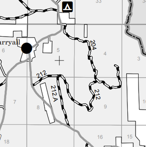
-On the map, it shows Forest Trail 204 in blue, which does not even show up on the MVUM at all.
-Then it shows 212.A in green, indicating it is “Full Size OHV Access,” while the rest of the system is Red, indicating “Main Route.” This doesn’t match the MVUM below:
-MVUM (South Park RD 2019) shows that entire system (212, 212.A, and 204) as a Road:
Pike-San Isabel National Forests & Cimarron and Comanche National Grasslands | Motor Vehicle Use Maps | Forest Service

-Motorized Travel Management Analysis (2022) indicates that China Wall 212, 212.A, and 204 are all a Road, open to all vehicles:
Appendix_B-1_Public_Routes_FinalROD.pdf | Powered by Box

-Stay the Trail list used to show China Wall on the full-size trail list, but now it is gone.
So what do you believe? The MVUM or the signage on the ground?
-On-site signage
-MVUM
-Motorized Travel Management Analysis
-Stay the Trail website
Example: China Wall
-On-site signage clearly indicates that it is an OHV Trail System. IMO this sign is really confusing.

-There is a sticker that says “Available Trail Designations For Vehicles Over 50” Wide” but the images show motorcycles, ATVs, SxS, and full-width. What is this sticker even trying to say?
-On the map, it shows Forest Trail 204 in blue, which does not even show up on the MVUM at all.
-Then it shows 212.A in green, indicating it is “Full Size OHV Access,” while the rest of the system is Red, indicating “Main Route.” This doesn’t match the MVUM below:
-MVUM (South Park RD 2019) shows that entire system (212, 212.A, and 204) as a Road:
Pike-San Isabel National Forests & Cimarron and Comanche National Grasslands | Motor Vehicle Use Maps | Forest Service

-Motorized Travel Management Analysis (2022) indicates that China Wall 212, 212.A, and 204 are all a Road, open to all vehicles:
Appendix_B-1_Public_Routes_FinalROD.pdf | Powered by Box

-Stay the Trail list used to show China Wall on the full-size trail list, but now it is gone.
So what do you believe? The MVUM or the signage on the ground?
60wag
Rising Sun Member
- Joined
- Aug 23, 2005
- Messages
- 2,650
Last weekend I was in Salida and was in the CO Parks and Wildlife office getting a fishing license with a friend. We asked about the OHV permit vs OHV registration for our plated motorcycles. The CPW person was adamant that the permit was only for out of state visitors and that the OHV registration was the right one for our street legal plated bikes.
When I got home I looked up the CPW page,
 cpw.state.co.us
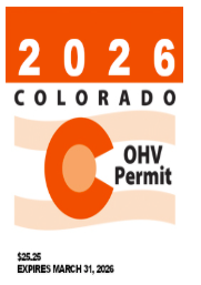
Yep, it appears that the permit would be correct for the plated motos. It looks like there are 2 versions of the permit, one is a non-stick green paper, the other is a decal. Decal is supposed to go on the upper fork.
I know the guy from Stay The Trail said permits for plated vehicles.
When I got home I looked up the CPW page,
Register an Off-Highway Vehicle
All Off Highway Vehicles must have either a current or valid Colorado Registration Card and two Decals or one Colorado Off Hi
I know the guy from Stay The Trail said permits for plated vehicles.
According to STT, anything with plates is supposed to have this one (the permit), which I have seen with my dad's plated bike and my Land Cruisers.Last weekend I was in Salida and was in the CO Parks and Wildlife office getting a fishing license with a friend. We asked about the OHV permit vs OHV registration for our plated motorcycles. The CPW person was adamant that the permit was only for out of state visitors and that the OHV registration was the right one for our street legal plated bikes.
When I got home I looked up the CPW page,
Yep, it appears that the permit would be correct for the plated motos. It looks like there are 2 versions of the permit, one is a non-stick green paper, the other is a decal. Decal is supposed to go on the upper fork.Register an Off-Highway Vehicle
All Off Highway Vehicles must have either a current or valid Colorado Registration Card and two Decals or one Colorado Off Hicpw.state.co.us
I know the guy from Stay The Trail said permits for plated vehicles.

Another Example: Red ConeYes, there was a ranger waiting as we were coming down Red Cone a couple weeks ago checking everyone who came down. He also stopped every sxs and checked for current registration & permits.
-no on-site signage indicating road vs. trail.
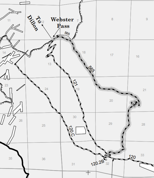
-MVUM (South Platte RD 2020) shows Red Cone (565) as a Road:
Pike-San Isabel National Forests & Cimarron and Comanche National Grasslands | Motor Vehicle Use Maps | Forest Service

-Motorized Travel Management Analysis (2022) indicates that Red Cone is a Trail, open to all vehicles.
-This table makes a mistake by putting part of Red Cone in the South Park RD instead of the South Platte RD, where it should be.
Appendix_B-1_Public_Routes_FinalROD.pdf | Powered by Box


-Stay the Trail list shows Red Cone as a Trail.
So I guess in this case there is a plan to update the MVUM to change Red Cone from a road to a trail. In the meantime do we follow the MVUM or what? How can the ranger be waiting for people to be coming off Red Cone and be handing out tickets when the MVUM shows it is a Road?
According to the MVUM page, MVUMs are to be updated annually, but that is clearly not happening (most recent Salida RD MVUM is 2017).
Good sleuthing Matt.Another Example: Red Cone
-no on-site signage indicating road vs. trail.
-MVUM (South Platte RD 2020) shows Red Cone (565) as a Road:
Pike-San Isabel National Forests & Cimarron and Comanche National Grasslands | Motor Vehicle Use Maps | Forest Service
-Motorized Travel Management Analysis (2022) indicates that Red Cone is a Trail, open to all vehicles.
-This table makes a mistake by putting part of Red Cone in the South Park RD instead of the South Platte RD, where it should be.
Appendix_B-1_Public_Routes_FinalROD.pdf | Powered by Box
-Stay the Trail list shows Red Cone as a Trail.
So I guess in this case there is a plan to update the MVUM to change Red Cone from a road to a trail. In the meantime do we follow the MVUM or what? How can the ranger be waiting for people to be coming off Red Cone and be handing out tickets when the MVUM shows it is a Road?
According to the MVUM page, MVUMs are to be updated annually, but that is clearly not happening (most recent Salida RD MVUM is 2017).
