You are using an out of date browser. It may not display this or other websites correctly.
You should upgrade or use an alternative browser.
You should upgrade or use an alternative browser.
9th Annual Spooky Night Run
- Thread starter nakman
- Start date
Air Randy
Hard Core 4+
giggidyQUOTE]
THE SNOW LEVEL WILL BE AROUND 10 THOUSAND FEET TODAY...AND THEN LOWER TO BETWEEN BETWEEN 8 AND 9 THOUSAND FEET TONIGHT. THERE WILL BE SOME HEAVY SNOW SHOWERS...AND THEY WILL BE MOST NUMEROUS IN THE NORTHERN FRONT RANGE MOUNTAINS LATE THIS AFTERNOON AND TONIGHT...WHERE ACCUMULATIONS OF 4 TO 10 INCHES ARE EXPECTED.
Right on bro!Bring the tire chains

Looks like the HEEP is parked tlll next season. Detroit up front and snow equals disaster expected. Give me time to get the winter projects started. Be safe gang....
Air Randy
Hard Core 4+
Looks like the HEEP and snow equals disaster expected. Give me time to get the winter projects started. Be safe gang....
I fixed it for you Kenny

LXBRADY
Hard Core 4+

FJCDan
Rising Sun Member
My wife and I will be there also, and maybe a couple of the Grand kids too. Looking forward to do some night snow wheeling it has been too long!!!
giggidyQUOTE]
THE SNOW LEVEL WILL BE AROUND 10 THOUSAND FEET TODAY...AND THEN LOWER TO BETWEEN BETWEEN 8 AND 9 THOUSAND FEET TONIGHT. THERE WILL BE SOME HEAVY SNOW SHOWERS...AND THEY WILL BE MOST NUMEROUS IN THE NORTHERN FRONT RANGE MOUNTAINS LATE THIS AFTERNOON AND TONIGHT...WHERE ACCUMULATIONS OF 4 TO 10 INCHES ARE EXPECTED.
Right on bro!
I will keep you all posted. I live above Central City at around 8,700 ft. No snow yet although it is a little chilly and breezy. No snow on the ground either but on the highest mountain peaks around there is a dusting.
Justin
simps80
Rising Sun Member
shamm wow
i thought i posted in this thread a while back ...
me and the kids will be there tonight
looking forward to it!!!
i thought i posted in this thread a while back ...
me and the kids will be there tonight
looking forward to it!!!
Inukshuk
Rising Sun Member
Lindsay works Sat night, thus my hesitant to go...
Have you even talked to the girl yet!??!
See ya'll soon. Boo Yah!
rover67
Rising Sun Member
heated seats are in!
Now time to get the wipers working...
Now time to get the wipers working...


Alright here we go... see everyone in Rollinsville in about 3 hours, remember it's at least an hour away from your house so start packing up.. we air down at 4:30, we leave at 5:00.
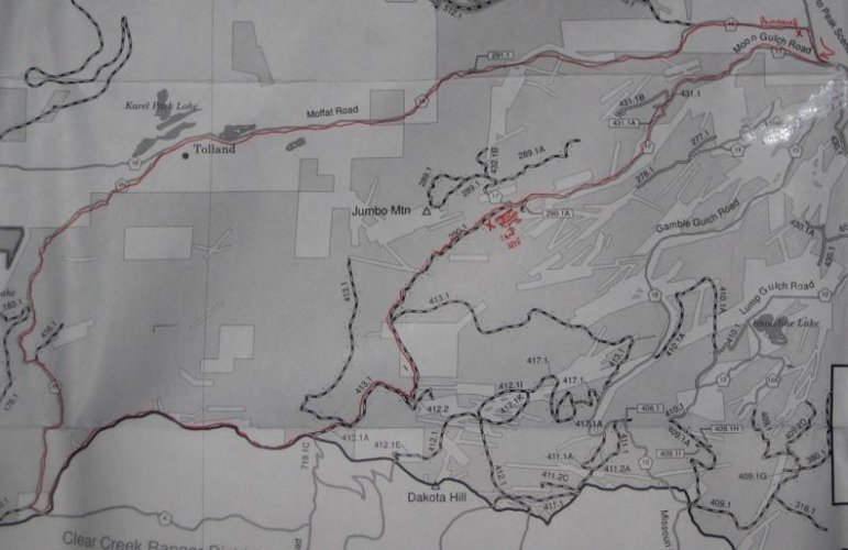
The trail we'll be running is called Moon Gulch, which will take us on a scenic trip around Jumbo Mountain. If you have one of those spiral bound Wells guides, you'll find this trail on page 105. We'll be getting back on the pavement in Rollinsville for about a quarter mile headed south towards Blackhawk, then will head west on Moon gulch Road. After about 2.5 miles of dirt road we'll slowly creep through some houses, then pause just briefly enough to flip to low range.
we'll be on FR 431.1. From there it's another 2 miles or so until we cross the intersection with 289.1, which will veer off to the right. We won't go there. Instead we'll stay left, and will suddenly be on FR 290.1. don't look at me I didn't name these things.. but from that intersection it's another half mile then we'll stop for the cookout site.
After the cookout the trees get considerably tighter, and the road narrows. We'll proceed up hill for another half mile or so until another intersection, where we'll take a left and be on 413.1. No that's not dyslexia yes I said 431 before and now it's 413, and no we didn't actually make any turns, the numbering just changed. But after this intersection we'll proceed another couple miles, through the tightest and most technical section of the trail. Please stay focused here- it's tight, there's a shelf that drops to the right, and there are numerous trees and branches on both sides and overhead. A nice chug in 2nd gear low range should be about perfect..
We will then drive through some snow then pop out on the top of a small incline to an open parking area near some camp sites, where we'll take a left turn downhill, going right past a very large cement barricade. If you pass big cement thing on the left you're in good shape, as you're on the right track and it's just a few switchbacks to a county road below. But wait, there's more....
Just as we get into the suburbs of Apex, we'll be taking a sharp right turn and will head due west, towards the Mammoth Gulch/Kingston Peak roads, which last about 2 miles, it's a wide open dirt road and will likely be as fast as you feel like going in low range. Once at the intersection with Kingston Peak, the official "run" will be headed right downhill towards Tolland, to complete the loop 12 miles away in Rollinsville. Please keep your speed in check in this final downhill section, as there are some very slick snowy areas well hidden on the other side of some sharp curves.. and it actually gets worse the further down we get.
Some folks in the group who are up for more adventure may choose to not do this section, and instead turn left at the intersection above, and head for either Kingston Peak or the "shortcut to Yankee hill" section that we ran on last year's Spooky run, providing for multiple options out. OTOH folks who want the guarantee to not get lost will be following me back down to Rollinsville.
Map is below, also a .pdf that's suitable for downloading and printing. Please dress warm, and toss another hat in the truck just in case. time to decorate the Cruiser...
The trail we'll be running is called Moon Gulch, which will take us on a scenic trip around Jumbo Mountain. If you have one of those spiral bound Wells guides, you'll find this trail on page 105. We'll be getting back on the pavement in Rollinsville for about a quarter mile headed south towards Blackhawk, then will head west on Moon gulch Road. After about 2.5 miles of dirt road we'll slowly creep through some houses, then pause just briefly enough to flip to low range.
we'll be on FR 431.1. From there it's another 2 miles or so until we cross the intersection with 289.1, which will veer off to the right. We won't go there. Instead we'll stay left, and will suddenly be on FR 290.1. don't look at me I didn't name these things.. but from that intersection it's another half mile then we'll stop for the cookout site.
After the cookout the trees get considerably tighter, and the road narrows. We'll proceed up hill for another half mile or so until another intersection, where we'll take a left and be on 413.1. No that's not dyslexia yes I said 431 before and now it's 413, and no we didn't actually make any turns, the numbering just changed.
But after this intersection we'll proceed another couple miles, through the tightest and most technical section of the trail. Please stay focused here- it's tight, there's a shelf that drops to the right, and there are numerous trees and branches on both sides and overhead. A nice chug in 2nd gear low range should be about perfect..We will then drive through some snow then pop out on the top of a small incline to an open parking area near some camp sites, where we'll take a left turn downhill, going right past a very large cement barricade. If you pass big cement thing on the left you're in good shape, as you're on the right track and it's just a few switchbacks to a county road below. But wait, there's more....
Just as we get into the suburbs of Apex, we'll be taking a sharp right turn and will head due west, towards the Mammoth Gulch/Kingston Peak roads, which last about 2 miles, it's a wide open dirt road and will likely be as fast as you feel like going in low range. Once at the intersection with Kingston Peak, the official "run" will be headed right downhill towards Tolland, to complete the loop 12 miles away in Rollinsville. Please keep your speed in check in this final downhill section, as there are some very slick snowy areas well hidden on the other side of some sharp curves.. and it actually gets worse the further down we get.
Some folks in the group who are up for more adventure may choose to not do this section, and instead turn left at the intersection above, and head for either Kingston Peak or the "shortcut to Yankee hill" section that we ran on last year's Spooky run, providing for multiple options out. OTOH folks who want the guarantee to not get lost will be following me back down to Rollinsville.
Map is below, also a .pdf that's suitable for downloading and printing. Please dress warm, and toss another hat in the truck just in case. time to decorate the Cruiser...
Attachments
Cool thanks  ... hey I'll be monitoring the connection all night, give me a shout any time for an update!
... hey I'll be monitoring the connection all night, give me a shout any time for an update!treerootCO
Rising Sun Member
- Joined
- Aug 22, 2005
- Messages
- 5,427
Starter fixed ") It was what I suspected...too much torque on the studs lifted the copper deals.
It was what I suspected...too much torque on the studs lifted the copper deals.

It was what I suspected...too much torque on the studs lifted the copper deals. Caribou Sandstorm
Hard Core 4+
We are bringing pizza, will have plenty for all the kids! Sorry not quite on theme but our kids are going to eat on the way..