Great Divide Expedition

Cruisertrash

Rising Sun Member
Joined
Aug 18, 2020
Messages
2,016
Location
Denver
Aim for sponsorship, land on RS club run? Sounds like an absolute win regardless.
I'm very interested.
I like this approach. A lot.

(logistics, team selection, insurance, ownership, liability, permits, etc...)
No matter who others sponsors might be - or whether that ends up happening at all - having this be a big Rising Sun event would take care of the liability insurance end of things. I'm sure that's contingent upon checking a few boxes to make it an "official" club event. Dom can probably clarify what that looks like. The ownership would then be Rising Sun I would assume. Permits would depend on the jurisdictions of the route and any potential permit areas within that, correct? Forest Service, various Ranger Districts, BLM land, etc? Lots more logistical hurdles beyond this, but I think those things would be high priority to have in place.
 

fyffer

Rising Sun Member
Joined
Sep 22, 2019
Messages
460
Location
Trinidad, CO
I just want to run it, 2024 even better. I know I will be running by then, for sure (1 way or the other).
Sign me up
 

DaveInDenver

Rising Sun Ham Guru
Joined
Jun 8, 2006
Messages
13,115
Location
Grand Junction
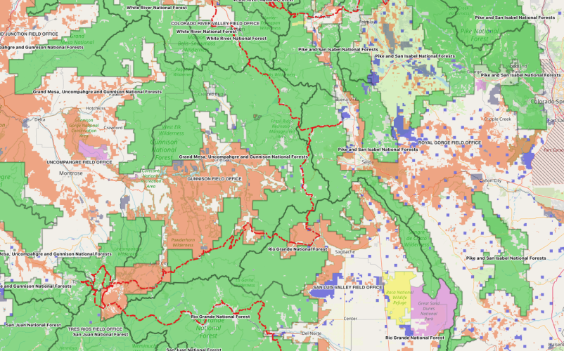
Hasty list of the Federal administrative units that this route I believe crosses.
  1. Medicine Bow – Routt N.F., Brush Creek – Hayden Ranger District
  2. Medicine Bow – Routt N.F., Hahns Peak – Bear’s Ear Ranger District
  3. Medicine Bow – Routt N.F., Parks Ranger District
  4. Arapahoe and Roosevelt N.F., Sulphur Ranger District
  5. Arapahoe and Roosevelt N.F., Boulder Ranger District
  6. Arapahoe and Roosevelt N.F., Clear Creek Ranger District
  7. Pike and San Isabel N.F., South Platte Ranger District
  8. White River N.F., Dillon Ranger District
  9. Royal Gorge BLM Field Office
  10. Pike and San Isabel N.F., South Park Ranger District
  11. Pike and San Isabel N.F., Leadville Ranger District
  12. White River N.F., Sopris Ranger District
  13. Colorado River Valley BLM Field Office
  14. White River N.F., Aspen Ranger District
  15. Grand Mesa Uncompahgre Gunnison N.F., Gunnison Ranger District
  16. Tres Rios BLM Field Office
  17. Pike and San Isabel N.F., Salida Ranger District
  18. Rio Grande N.F., Saguache Ranger District
  19. San Luis Valley BLM Field Office
  20. Gunnison BLM Field Office
  21. San Juan N.F., Columbine Ranger District
  22. Rio Grande N.F., Divide Ranger District
  23. Rio Grande N.F., Conejos Peak Ranger District
 
Last edited:

Cruisertrash

Rising Sun Member
Joined
Aug 18, 2020
Messages
2,016
Location
Denver
Hasty list of the Federal administrative units that this route I believe crosses.
  1. Medicine Bow – Routt N.F., Brush Creek – Hayden Ranger District
  2. Medicine Bow – Routt N.F., Hahns Peak – Bear’s Ear Ranger District
  3. Medicine Bow – Routt N.F., Parks Ranger District
  4. Arapahoe and Roosevelt N.F., Sulphur Ranger District
  5. Arapahoe and Roosevelt N.F., Boulder Ranger District
  6. Arapahoe and Roosevelt N.F., Clear Creek Ranger District
  7. Pike and San Isabel N.F., South Platte Ranger District
  8. White River N.F., Dillon Ranger District
  9. Royal Gorge BLM Field Office
  10. Pike and San Isabel N.F., South Park Ranger District
  11. Pike and San Isabel N.F., Leadville Ranger District
  12. White River N.F., Sopris Ranger District
  13. Colorado River Valley BLM Field Office
  14. White River N.F., Aspen Ranger District
  15. Grand Mesa Uncompahgre Gunnison N.F., Gunnison Ranger District
  16. Pike and San Isabel N.F., Salida Ranger District
  17. Rio Grande N.F., Saguache Ranger District
  18. San Luis Valley BLM Field Office
  19. Gunnison BLM Field Office
  20. San Juan N.F., Columbine Ranger District
  21. Rio Grande N.F., Divide Ranger District
  22. Rio Grande N.F., Conejos Peak Ranger District
What would we do without you Dave? We’ve never met but just through forum posts and our chats I’m beginning to understand that your brain is a machine and if we turn you loose on something you come back with detailed results!
 

nakman

Club Secretary
Staff member
Moderator
Joined
Aug 23, 2005
Messages
14,605
Location
north side
I like this approach. A lot.


No matter who others sponsors might be - or whether that ends up happening at all - having this be a big Rising Sun event would take care of the liability insurance end of things. I'm sure that's contingent upon checking a few boxes to make it an "official" club event. Dom can probably clarify what that looks like. The ownership would then be Rising Sun I would assume. Permits would depend on the jurisdictions of the route and any potential permit areas within that, correct? Forest Service, various Ranger Districts, BLM land, etc? Lots more logistical hurdles beyond this, but I think those things would be high priority to have in place.
I don't get where this is coming from. An "official" club run is generally our club adopt-a-trail efforts, and this isn't it. And even those don't require permits and insurance. You're trying to organize a group to go on a road trip... that's great, sounds fun, why the added overhead?
 

Cruisertrash

Rising Sun Member
Joined
Aug 18, 2020
Messages
2,016
Location
Denver
I don't get where this is coming from. An "official" club run is generally our club adopt-a-trail efforts, and this isn't it. And even those don't require permits and insurance. You're trying to organize a group to go on a road trip... that's great, sounds fun, why the added overhead?
Club run wasn’t my idea, just something I agreed with. It’s in the spirit of other clubs runs - and there are many beyond the clean up runs. Doesn’t have to be that, and maybe I should read the club’s mission. Do we have a mission/vision statement?
 

Burt88

Trail Ready
Joined
Sep 7, 2013
Messages
362
Location
Montrose, CO
Seems to me that a group needs to just do the whole thing and allow folks to join for segments. Why is this such a big deal? Why does this need some official status or sponsorship right out of the gate? Just go do it, have fun, film it, take notes, collect data, then come back with a full report and then try to produce some big event out of it.
 

Crash

Rising Sun Member
Joined
Aug 23, 2005
Messages
3,874
Location
Denver
This is great, thanks for sharing! It is a great reminder of how it felt like traveling Colorado in the late 80's early 90's, as a kid it really solidified my passion for the great outdoors and our wonderful state.

I believe the route from Leadville to Aspen may be Via Hagerman Pass.
I don't think they took tin cup, It looks like they might have turned in the town of Tincup and taken Cumberland pass to Pitkin.

What I am very curious about is how they made it from Aspen to Taylor Park? I've never seen a way that connects the two and I've been curious nearly my whole life. Anyone know?
Ask Bill Burke.
This is great, thanks for sharing! It is a great reminder of how it felt like traveling Colorado in the late 80's early 90's, as a kid it really solidified my passion for the great outdoors and our wonderful state.

I believe the route from Leadville to Aspen may be Via Hagerman Pass.
I don't think they took tin cup, It looks like they might have turned in the town of Tincup and taken Cumberland pass to Pitkin.

What I am very curious about is how they made it from Aspen to Taylor Park? I've never seen a way that connects the two and I've been curious nearly my whole life. Anyone know?
I’m guessing Bill Burke might have some answers for you.
 

HDavis

Hard Core 4+
Joined
Feb 13, 2019
Messages
1,140
My initial route is Leadville over Hagerman to Aspen. That's the obvious route and AFAIK the only OHV/MTB through Hunter-Frypan Wilderness. West of Hagerman but not yet starting to boogie down FS105 there's a good spur I know of that leads to a group camp.


I'm giving away one of my favorite spots to camp but there is a huge 10th mtn division hut on the west side of Hagerman. If I recall correctly its up FS527. There is a really great pond that's covered in Lily pads that bloom every late summer nearby. Fittingly named Lily Pad Lake.

The website gives a capacity of 16 to people. There is plenty of camping in the area as well.


Crash

Rising Sun Member
Joined
Aug 23, 2005
Messages
3,874
Location
Denver
I'm giving away one of my favorite spots to camp but there is a huge 10th mtn division hut on the west side of Hagerman. If I recall correctly its up FS527. There is a really great pond that's covered in Lily pads that bloom every late summer nearby. Fittingly named Lily Pad Lake.

The website gives a capacity of 16 to people. There is plenty of camping in the area as well.

Camped there with James Bingham in 2008 before there was a hut there. Beautiful spot.
 

HDavis

Hard Core 4+
Joined
Feb 13, 2019
Messages
1,140
Will pull out the gazetteer tonight.
Do you use yours to mark favorite places, routes taken, people traveled with, and years? Its one of the main reasons we keep ours around still. I really appreciate them as tangible memories.
 

Crash

Rising Sun Member
Joined
Aug 23, 2005
Messages
3,874
Location
Denver
Do you use yours to mark favorite places, routes taken, people traveled with, and years? Its one of the main reasons we keep ours around still. I really appreciate them as tangible memories.
Your use of the gazetteer sounds like something we should have done. Suz has highlighted trails we’ve been on but writing names of fellow travelers would have been a great thing to do. I still, being an oldtimer, use the maps we’ve collected over the years. Especially the old ones that show trails that aren’t on newer ones or GPS.
 

Crash

Rising Sun Member
Joined
Aug 23, 2005
Messages
3,874
Location
Denver
Glad Suz has highlighted trails in the gazetteer as it would have been difficult to find this little lake again otherwise. Diemer Lake is shown being either on FR532 or 502 just north of the Coke Oven State Wildlife Area. Beautiful and secluded. The FR shown going northwest of Diemer Lake was not open to travel at the time.
Halfmoon to Hagerman 183.jpg
(y)
 
Last edited:

njarrett

Rising Sun Member
Joined
Oct 9, 2022
Messages
5
Hi all, I'm blown away by the interest and research the group has put together. There are a lot of good ideas here that I think are worth discussing more, but it'd probably be easier in person at the next meeting. Ill work with Dom and Angelo to introduce me to everyone so we can get a good side chat going at the meeting.

For some updates, I've also had good traction on the LR forums and fb pages and was able to get a copy of the exact route they took. I mapped it in gaia and it certainly has some accessibility issues with today's access, or like was said before being normal people and not LR. Tom Collins, the original organiser, did a heck of a good job with this.

I like the idea of a group. That said I'm not much of a manager of people. Cool to see what this post has lead to. At any rate please don't get a group together and do this without me haha.

Q's
- Getting around Rollins, I'm leaning towards Berthoud since I primarily wheel in the front range and have seen a decent bit of that part of the route. Not sure how permanent the barrier on Rollins is but it'd be cool if we could get approval from the forest service for a one time pass if it's not physically impossible.
- Sargents to Cochetopa Pass, the only part of the route that gets vague in Tom's notes. The best I can tell the original route is atv/dirt bike only now . There's certainly a way through but not sure what the best route would be.


A's
@HDavis - that's right they turned east at tincup and went to the Princeton hot springs for some R&R
@DaveInDenver - they did indeed drive up the lifts in Aspen. Your first day is nearly dead on.
@BritKLR - sending you a dm, we should talk more about your group trip and sponsorship points. I have had similar thoughts
@DaveInDenver - They spent an extra day in the San Juan's so they could retrace over black bear. Again your day 8-12 is very very close
@Cruisertrash - yep, a lot of the routes I'm seeing give us a pretty narrow late August early September window
@DaveInDenver - I agree reaching out to forest service, BLM and sheriffs offices is going to be the key to success here. There are a lot of private property and mining claims that could potentially reroute lesser known portions
@Burt88 - I think you nailed it, this was my original intention. It should be fun first and foremost

Thanks again everyone, I've been really impressed by the interest.
 
Last edited:

SaintAgatha

Rising Sun Member
Joined
Sep 25, 2021
Messages
198
Location
Dumont
First I have to admit that I have not read every post in this thread, so if I missed something or you have this figured out, apologies.

But one of the Rebelles, Thayer Gray, is the president of some local Land Rover club. I mentioned this discussion to her and said that she might be able to find the original route, if you are interested.

She also knows the whereabouts of at least one of the original trucks, which I thought was pretty cool.
 
Top