A Grand Reopening Win: Conservation Leasing Scheme Cancelled

timmbuck2

Land Use Coordinator
Staff member
Cruise Moab Committee
Joined
Oct 5, 2005
Messages
6,102
Location
Denver

The Bureau of Land Management’s (BLM) Conservation and Landscape Health Rule, finalized in June 2024, sought to prioritize conservation as a valid use of public lands under the Federal Land Policy and Management Act (FLPMA) of 1976. This rule introduced conservation leases, allowing entities to lease public lands for conservation efforts, and expanded Areas of Critical Environmental Concern (ACECs) by designating certain research and protection areas as ACECs.


This rule effectively sidelined traditional land uses like grazing, mining, and recreation, potentially leading to the largest privatization scheme of public lands from multiple-use access in U.S. history. BlueRibbon Coalition (BRC), opposed the rule from the beginning starting in 2023, asserting that it lacked proper congressional authorization and would limit any recreation access to public lands that wasn’t considered casual use. Courts don’t recognize motorized recreation as casual use, so this rule would have certainly been used to enact substantial restrictions on motorized access to public lands.


Thousands of our members made the difference in opposing this rule.


In response to this rule, the Western Economic Security Today (WEST) Act was introduced in early 2024. BRC and our members rallied to support the repeal of the Conservation and Landscape Health Rule. While the WEST Act nullifies the rule, it does not prevent similar regulations from being enacted in the future which we will need legislation to do so.


Throughout the rule's development, BRC actively opposed its implementation, encouraging public comments and considering legal action. Numerous litigation challenges were filed against this rule, and we were in the due diligence phase of participating in a litigation challenge. However, with the change in administration and the introduction of the WEST Act, BRC paused paused our efforts toward litigation efforts because of anticipated policy reversals.


Recently the Trump administration announced the rescission of the BLM rule which was a massive victory for BRC and our members. We couldn't have done it without all the support from members like you.


In addition to this win, today we learned that the U.S. Senate passed the legislation to permanently reopen 24 miles of trails that were closed to OHV use in Glen Canyon.


The Grand Reopening is picking up speed, and with your help we’re going to open the throttle.


Simone Griffin,

Policy Director
 

BritKLR

Vice Commander
Joined
Oct 29, 2012
Messages
2,314
Location
ATC HQ - Nederland, Colo.

The Bureau of Land Management’s (BLM) Conservation and Landscape Health Rule, finalized in June 2024, sought to prioritize conservation as a valid use of public lands under the Federal Land Policy and Management Act (FLPMA) of 1976. This rule introduced conservation leases, allowing entities to lease public lands for conservation efforts, and expanded Areas of Critical Environmental Concern (ACECs) by designating certain research and protection areas as ACECs.


This rule effectively sidelined traditional land uses like grazing, mining, and recreation, potentially leading to the largest privatization scheme of public lands from multiple-use access in U.S. history. BlueRibbon Coalition (BRC), opposed the rule from the beginning starting in 2023, asserting that it lacked proper congressional authorization and would limit any recreation access to public lands that wasn’t considered casual use. Courts don’t recognize motorized recreation as casual use, so this rule would have certainly been used to enact substantial restrictions on motorized access to public lands.


Thousands of our members made the difference in opposing this rule.


In response to this rule, the Western Economic Security Today (WEST) Act was introduced in early 2024. BRC and our members rallied to support the repeal of the Conservation and Landscape Health Rule. While the WEST Act nullifies the rule, it does not prevent similar regulations from being enacted in the future which we will need legislation to do so.


Throughout the rule's development, BRC actively opposed its implementation, encouraging public comments and considering legal action. Numerous litigation challenges were filed against this rule, and we were in the due diligence phase of participating in a litigation challenge. However, with the change in administration and the introduction of the WEST Act, BRC paused paused our efforts toward litigation efforts because of anticipated policy reversals.


Recently the Trump administration announced the rescission of the BLM rule which was a massive victory for BRC and our members. We couldn't have done it without all the support from members like you.


In addition to this win, today we learned that the U.S. Senate passed the legislation to permanently reopen 24 miles of trails that were closed to OHV use in Glen Canyon.


The Grand Reopening is picking up speed, and with your help we’re going to open the throttle.


Simone Griffin,

Policy Director
Thanks for the update!
 

nakman

Rising Sun Member
Staff member
Joined
Aug 23, 2005
Messages
15,739
Location
north side
In addition to this win, today we learned that the U.S. Senate passed the legislation to permanently reopen 24 miles of trails that were closed to OHV use in Glen Canyon.

Anyone know what this route is? Exactly what was closed, and is now reopened?
 

DaveInDenver

Rising Sun Ham Guru
Joined
Jun 8, 2006
Messages
14,347
Location
Grand Junction
Anyone know what this route is? Exactly what was closed, and is now reopened?
What the Senate passed May 8, 2025:
https://www.congress.gov/bill/119th-congress/house-joint-resolution/60

Appears to have nullified this NPS rule:
https://www.federalregister.gov/doc...anyon-national-recreation-area-motor-vehicles

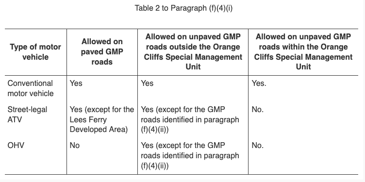
"The rule prohibits the use of OHVs and street-legal ATVs on an 8-mile segment of the Poison Spring Loop located on Route 633 proceeding north to Route 730 in the Orange Cliffs Special Management Unit, identified in Table 2 to paragraph (f)(4)(i) in the existing special regulations."

"This final rule also prohibits OHV and street-legal ATV use on the following unpaved GMP roads in the Recreation & Resource Utilization Zone that is defined in the GMP:

  • Unnamed road near Dry Mesa/Sheep's Canyon near Hite, sometimes referred to as Dry Mesa Road (approximately 4.31 miles).
  • Road #2/95 Spur near Hite, also known as Dirty Devil Spur (approximately 1.14 miles).
  • Cove Canyon Spur Road near Hite (approximately 0.65 miles).
  • Flint Trail Spur Road near Hite, also known as Waterhole Flat Spur #1 Road & Dark Canyon Overlook Road (approximately 0.72 miles).
  • Ticaboo Mesa Road near Bullfrog (approximately 1.45 miles).
  • Muley Point Road (approximately 1.26 miles).
  • Johns Canyon Road near Muley Point (approximately 7.49 miles)."
If my math is correct this adds up to 25.02 miles. I have not done any work to verify them in GIS, so no map to offer for visual impact.

Also haven't followed this close enough but there's been a lot of head butting with BLM and NPS over side-by-sides driving roads where you're supposed to be a licensed, road legal vehicle. Thus I don't know if OHV in this context is (or was, the rule is no more) all motorized vehicles or not. I'm inclined to assume these routes were never closed to us.

Screenshot 2025-05-13 at 11.57.40.png
 
Last edited:

nakman

Rising Sun Member
Staff member
Joined
Aug 23, 2005
Messages
15,739
Location
north side
thanks Dave... it's a wonder that anyone can make sense of this stuff. If I search for those roads in Gaia I get pretty much the whole Poison Springs wash area...
1747163023499.png


which doesn't make a lot of sense as I'm pretty sure that road isn't closed, and hasn't been... I know guys here who ran it as recently as last October. In our own group speak, it's the route that would allow you to Exit the Maze and go through the Dirty Devil, then out towards Hanksville. Must have been a spur or something? I'll just celebrate that it's open again, and move on.
 

DaveInDenver

Rising Sun Ham Guru
Joined
Jun 8, 2006
Messages
14,347
Location
Grand Junction
There's a couple I'm not familiar with but I think I've managed to decipher their descriptions for ones I do know.

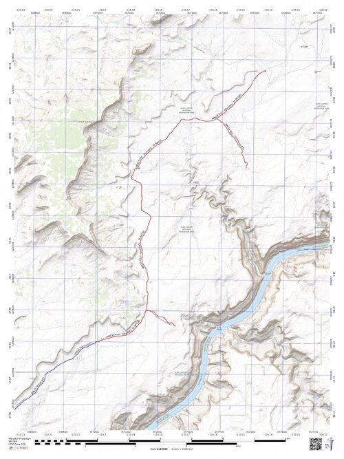
The section of NP633 that you're talking about Tim looks like it's from the NPS border to NP730. The part I've made red as opposed to blue. The whole length of 633 from UT95 to the road to Sunset Pass is about 32 miles. I've also shown the Dark Canyon Overlook Spur they intended to close.

np633toNP730.jpg

This is Dry Mesa Road. Here again the length given would only represent the part contained inside the NPS boundary, not the length on BLM land, Bears Ears or county roads that eventually connect it back to UT95. My speculation here would be that users of Cataract and Dark Canyons have something to do with this.

drymesaroad.jpg

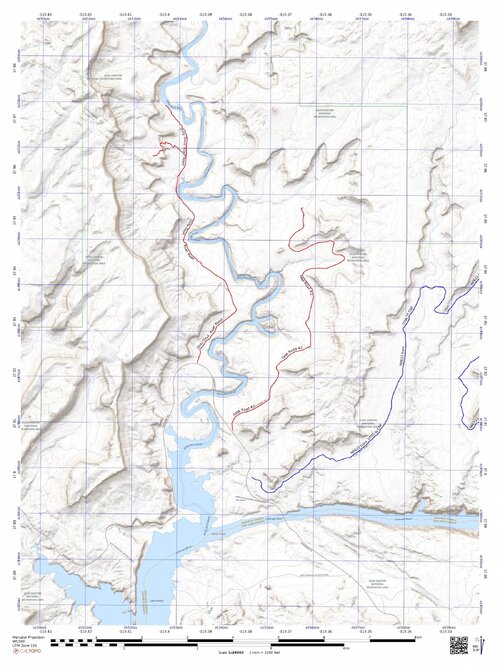
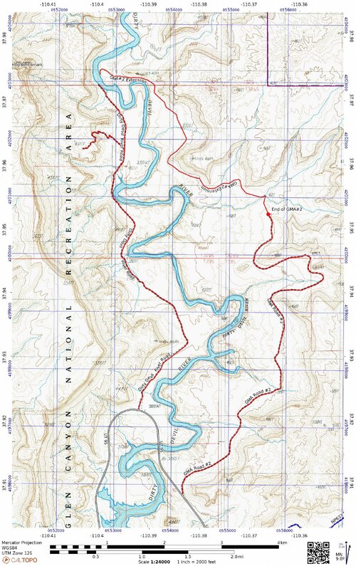
I'm pretty sure they're talking about a spur from the road to the west of the Dirty Devil River but there may be an unmapped spur off the #2 Road, which is to the east of the river.

dirtydevilspur.jpg

Although, on old scanned topos there is a ~3 mile length of road shown that may have at some time gone all the way to the river.

8DLMS.jpeg

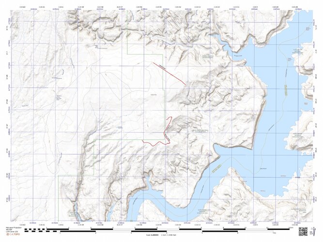
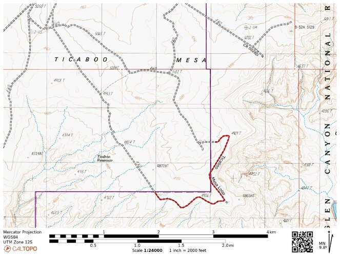
Ticaboo Loop. Again, this length seems to imply only the part within the NPS managed land, there's a bunch of roads on the BLM side of the line.

ticabooloop.jpg

QN4C8.jpeg
 
Last edited:

DaveInDenver

Rising Sun Ham Guru
Joined
Jun 8, 2006
Messages
14,347
Location
Grand Junction
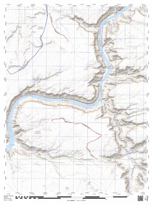
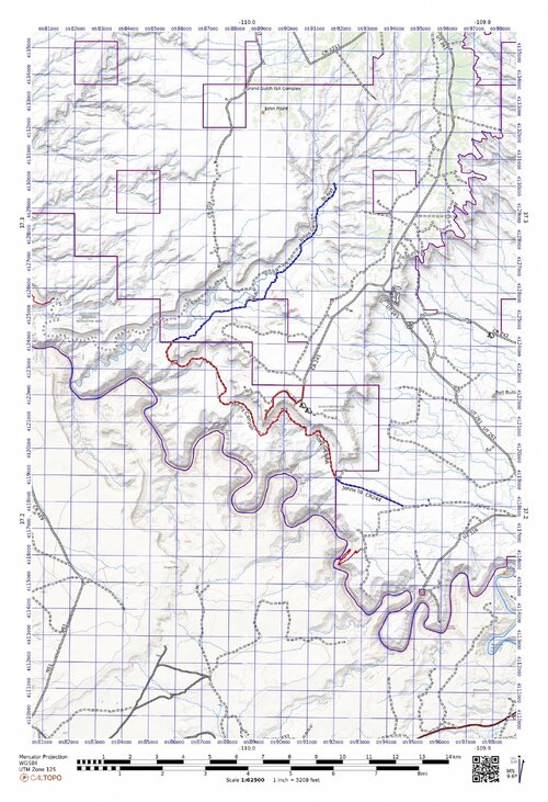
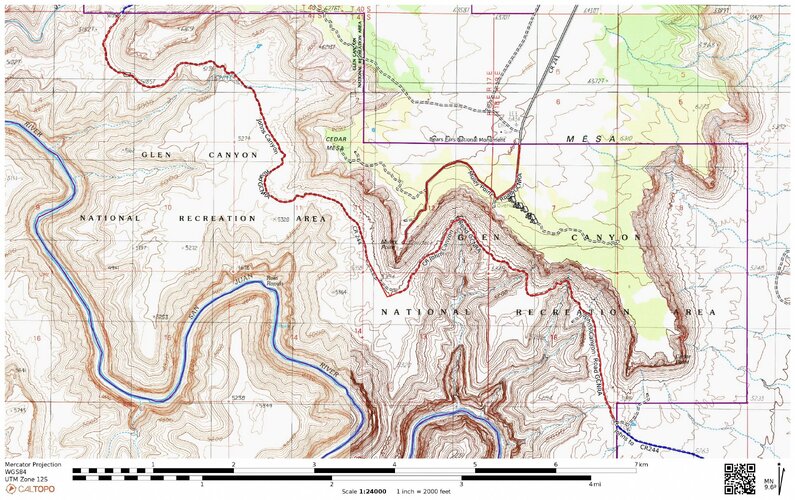
Then the Johns Canyon road and Muley Point road. These are by the Goosenecks. The length shown in red is within the GCNRA while the blue lengths of Johns are on BLM land.

johns-and-muley.jpg

DBPNG.jpeg
 
Back
Top