Kokopelli questions

KCJAZ

Wincher
Joined
Feb 1, 2025
Messages
54
I'm think about doing Kokopelli to kick off my first Cruise Moab. The trail description is helpful but I want to make sure I have the right locations for camping the night before and the trail head. Are the below right (Jouflas Campground by red X, and Google found "trail start" for trail head)?

1739816697697.png


Also, does anyone have a GPX file I can use with OnX for the route? I see several sections and trails called Kokopelli but not one continuous Kokopelli route shown in OnX. I'd assume that we'd generally follow the river and maybe have to hop on some pavement in spots?
 

timmbuck2

Land Use Coordinator
Staff member
Cruise Moab Committee
Joined
Oct 5, 2005
Messages
6,005
Location
Denver
@allen.wrench is one of our Kokopelli experts, I am sure he will chime in
 

KCJAZ

Wincher
Joined
Feb 1, 2025
Messages
54
Found this Mud thread which provides lots of good info and confirmed my location questions above. It sparked another question though. The pics of the rigs all had roof top tents. If I convince my buddy to go, we will have a ground tent. As I am a total newbie with Moab desert camping, I'm wondering about tent spikes in rock. One of the pics showed the rigs camping on what looked like all slick rock. Use small rocks for anchors? Hammer drill and tapcons? (just kidding on the last one).
1739821352753.png
 

Pz10420

Hard Core 4+
Joined
Jun 21, 2020
Messages
663
You can usually find a dirt spot somewhere nearby that you can put stakes in. Just make sure to put something with a little weight to it in the tent in case the winds get going in case your stakes aren't in the ground that well, cause sometimes the ground is pretty sandy.
 

Notyourmomslx450

GIG 'EM GILL
Staff member
Cruise Moab Committee
Joined
Aug 4, 2014
Messages
4,385
Location
Westminster
like @On the RX said..... rocks in the corners inside the tent
 

Inukshuk

Rising Sun Member
Joined
Aug 24, 2005
Messages
8,641
Location
Denver, CO
Welcome. Glad the Mud thread helped.
That was a stop to dry tents. All camping is on sand and dirt. I ground tent it with regular long stakes.
We start Koko at Jouflas which is right off I70 at the Rabbit Valley exit but the dirt road from Loma you highlight is part of the official trail maps and perfectly pleasant section of gravel/dirt road.
 

allen.wrench

Rising Sun Member
Joined
Dec 7, 2018
Messages
758
Location
Syracuse, UT
Good questions. Lots of good questions.

The campsite the night before Kokopelli has generally been Jouflas Campground, about how you have marked with the red X. We have also played it by ear, depending on the weather, space availability, and fees, we have stayed across i70 at High North Campground. Both the green circles in the screenshot below are great spots. For the group I lead this year, like prior years, I plan to share a detailed planning/itinerary email as the dates approach, and we know who is in this year's Kokopelli run. Good find of the Mud thread, @Inukshuk, has done a splendid write-up. I have always shared Daniel's write-up in my Kokopelli Krew emails over the last few years.

Please note, in my opinion, the campsite the night before Kokopelli is not a "make or break" part of being on the Kokopelli run. Kokopelli begins on the first morning with the driver meeting, CM waivers, truck inspections, trial etiquette, group intro, air down, radio checks, and saddle-up in the dirt lot just barely south of i70 circle below in blue.

That picture you grabbed from Mud was from the 2nd night on the Tues-Thurs Kokopelli I lead in CM 2023. Normally the 2nd night is at Robert's Bottom (RB) by the river and cliff bottom. But we had a small group of about 6 or 7 trucks, we were fast & nimble. After getting to Robert's Bottom two trucks went scouting a short lil bit, where they found that spot about halfway between RB and the trail head to Top of the World. After the scouts came back and shared the news with the group, there was still good daylight, and we all decided to relocate the 2nd night to be up high on top of RB. Those rigs with the root top tents (RTTs) just took the slickrock cuz it's what they do. Right below them where the photographer was standing, the ground was plenty sandy enough for ground tenting. My co-pilot friend that year was ground tenting while I slept in the bed of my Tacoma. All were happy campers.

Hammer drill and Tapcons not required. Please don't drill/bolt into the areas we explore. They do get chewed up as-is and we do what we can to leave areas nicer than we found them, like we'll see who can collect the most interesting pieces of trash along the trail. We want to continue exploring these areas for generations cuz they're amazing areas in this world. All the same, if you are prepped with a hammer drill and Tapcons, I'd love to check out your storage/organization methods.

Fish Ford (FF) and RB are the two official campsites we use on the 1st and 2nd nights of Kokopelli respectively. Both are great for RTTs, ground tents, hammocks, etc. If there's a situation that causes us trouble, we'll figure things out together for the welling being of the team.

If you'd like, you're welcome to look over the hard copy maps I carry. You're also welcome to record our Kokopelli trail this year as we drive it.

Things become clearer as we get closer to the date and get into it all :D all the same, good questions. Keep them coming.

Allen

1739820848125.png
 

KCJAZ

Wincher
Joined
Feb 1, 2025
Messages
54
Built an OnX Route for Kokopelli (can you tell I'm excited for this?). There looks to be a lot of potential variations and likely some "on the fly" route changes based on conditions needed. OnX shows a lot of "unknown motorized access" trails and I used a few in my routes which may not be valid. This was just an exercise that enabled me to avoid work a bit today and to start getting my "bearings" for this trip if only virtually.

1739839865046.png


Definitely will record our track as we go.
 

subzali

Hard Core 4+
Joined
Aug 22, 2005
Messages
10,798
Location
Denver CO
I love mapping routes. Unfortunately I haven’t done the Koko with Cruise Moab, did it with some friends last October on motorcycles. So my route might be a little different. But we did Dome Plateau as part of it, which looks like you are bypassing.

We also did Rose Garden Hill. Is there a reason you’re bypassing Rose Garden? You have a lot of Hwy 128 in there, if you intended to bypass Rose Garden you should catch it again at Onion Creek to go up to Hideout Canyon Road into the La Sals I think.

I will look at my kmz file later of the ride we did and see how it compares with your route. If you follow the route on Google Earth it’s labeled “Kokopelli Safari Route” or something like that.
 

subzali

Hard Core 4+
Joined
Aug 22, 2005
Messages
10,798
Location
Denver CO
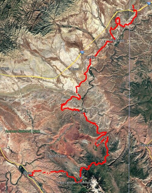
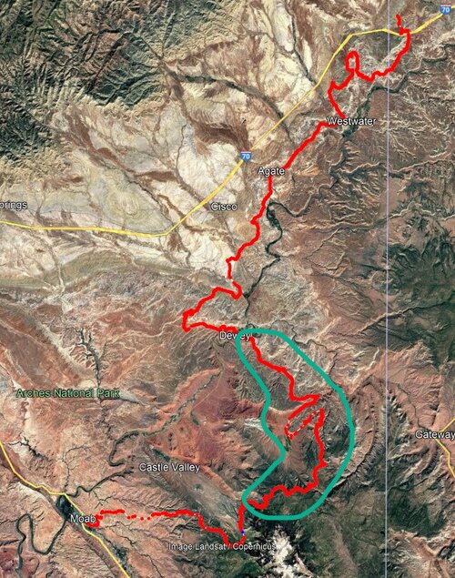
Here is my track on Google Earth of the trip we did.
koko oct 2024.jpg

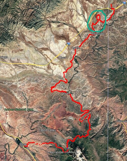
Getting out of Rabbit Valley looks different than what you have. Here:
koko oct 2024-rabbit valley.jpg

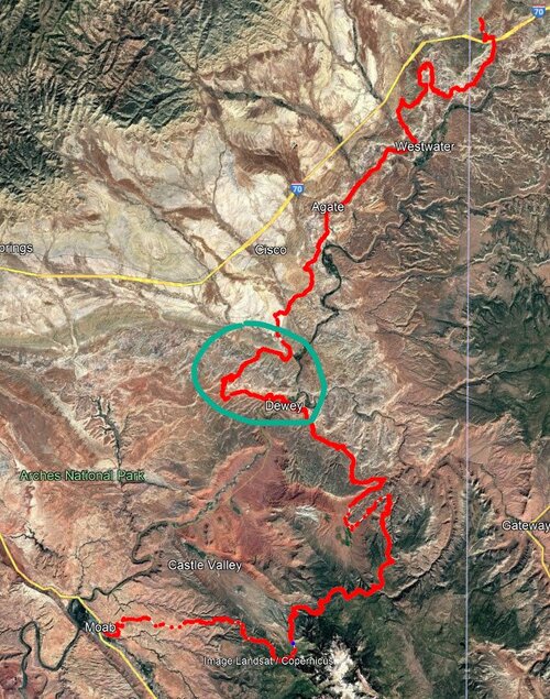
Here is the Dome Plateau section we did:
koko oct 2024-dome plateau.jpg

And then Rose Garden/Beaver Mesa/La Sal section looks different from yours as well:
koko oct 2024-rose garden and beaver mesa.jpg
 

DaveInDenver

Rising Sun Ham Guru
Joined
Jun 8, 2006
Messages
14,252
Location
Grand Junction
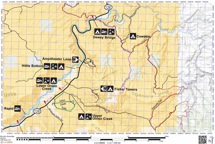
Yes, @subzali, if you skip Rose Garden the alternate is UT128 from Dewey Bridge south to Onion Creek Road. I show Top of the World, which if you skip Rose Garden might be a nice option, Dewey up to TOTW, backtrack to pavement and run Onion Creek to join below.

LVJAJ.jpeg

Kokopelli Trail north terminus is the parking lot off the Loma exit from I-70. It's a short dirt road from roughly the State Patrol weigh station.

I show the MTB route in blue with a couple of alternatives near Rabbit Valley. The blue between Loma and Mack at the northern end is MTB only, motos are not allowed on singletrack there. OHV and MTBs routes join after Salt Creek.

So most of the time OHVs skip the section from Loma to Rabbit Valley since it's just improved gravel dirt roads and a length of two lane Federal highway. Between Salt Creek and Rabbit Valley there are a few motorcycles options but it's out-and-backs so not much reason to stray from the frontage road.

The 4WD route is red, which motos would have to follow with the main notable exception being in Rabbit Valley motorcycles are allowed on singletrack, so there are few side trails you can explore if you wish parallel to the Kokopelli itself. Many people do not add singletrack, the double track main route isn't dull and plenty of work.

The MTB route along the Colorado River east of McGraw Bottom is also off limits to motos.

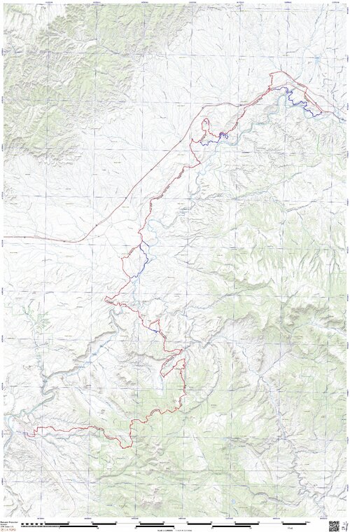
These are a couple of my as-run tracks, hopefully the resolution is low enough not to upset anyone's anticipation and planning. It does show Yellowjacket Canyon/Dome Plateau route.

UFQNT.jpeg

@allen.wrench (and CM planners) it should be mentioned that all 5 campgrounds around Rabbit Valley are now designated and require reservation. That includes north of I-70.

 
Last edited:

Inukshuk

Rising Sun Member
Joined
Aug 24, 2005
Messages
8,641
Location
Denver, CO
But we did Dome Plateau as part of it, which looks like you are bypassing.
Dome is part of the route
We also did Rose Garden Hill. Is there a reason you’re bypassing Rose Garden?
We, Cruise Moab, made the decision to remove rose garden Hill from the run several years ago. Simply because it is a very difficult section - like everything it’s gotten more dug out - which is inconsistent with the generally laid-back over landing nature of the Kokopelli trip.

The first OnX route of the Kokopelli Trail was submitted by me and had my name associated with the notes. As one of their trail guides. Unfortunately, at some point during some change over within OnX, they must’ve felt somebody else was more important and took me off of it.

No matter what notes anybody posts up here, the Cruise Moab route is determined by the Cruise Moab committee and trail leader under the allowable permitted routes. Trail leading is which now is the very competent @allen.wrench who I was privileged to have as my tail and mid Gunner for several of the years that I led the trip.
 
Last edited:

subzali

Hard Core 4+
Joined
Aug 22, 2005
Messages
10,798
Location
Denver CO
Dome is part of the route

We, Cruise Moab made the decision to remove rose garden Hill from the run several years ago. It’s simply because it is a very difficult section - like everything it’s gotten more dug out over the - that was inconsistent with the generally laid-back over landing nature of the Kokopelli trip.

The first OnX route of the Kokopelli Trail was submitted by me and had my name associated with the notes. As one of their trail guides. Unfortunately, at some point during some change over within OnX, they must’ve felt somebody else was more important and took me off of it.

No matter what notes anybody posts up here, the cruise moab route is determined by the Cruise Moab committee and trail leader, which now is the very competent @allen.wrench who I was privileged to have as my tail and mid Gunnar for several of the years that I led the trip.
Yeah Rose Garden was very difficult, even going downhill, on a dirtbike, this last fall. So bypassing it is a sound idea esp. with a group.
 

DaveInDenver

Rising Sun Ham Guru
Joined
Jun 8, 2006
Messages
14,252
Location
Grand Junction
Yeah Rose Garden was very difficult, even going downhill, on a dirtbike, this last fall. So bypassing it is a sound idea esp. with a group.
I most def do not judge anyone. I won't beat the truck up anymore trying, hate even trying on a dirt bike (but I suck at technical on it, so there's that) and walk as much as I ride on a MTB. Some years are worse depending on the run-off debris and how the lines form, though as a matter of course CM bypassing makes a lot of sense.
 

KCJAZ

Wincher
Joined
Feb 1, 2025
Messages
54
Here is my track on Google Earth of the trip we did.
koko oct 2024.jpg

Getting out of Rabbit Valley looks different than what you have. Here:
koko oct 2024-rabbit valley.jpg

Here is the Dome Plateau section we did:
koko oct 2024-dome plateau.jpg

And then Rose Garden/Beaver Mesa/La Sal section looks different from yours as well:
koko oct 2024-rose garden and beaver mesa.jpg
Yes bypassing RGH for reasons others have stated. Thanks for calling out Dome Plateau to Dewey Bridge. Way better than 128. I was just trying to get from A to B. Also Onion Creek (thanks @DaveInDenver) look better than my 128/96 route from Dewey.

What's the path from Fish Ford camp to the trail head of Dome Plateau? I had ploted the bit in blue but I'm not sure that will work as OnX just says "unknown motorized access" plus it looks like part of that path is on the river bank. The only for sure route I see is Cisco Pumpkin House Rd to 175 to 128.
1739908084221.png


At any rate, I'm just having fun here getting my head wrapped around this trip. Fully understand (and appreciate) Trail Leaders are called Trail Leaders for a reason and I'm looking forward to following the bumper in front of me. CM (really attending any national TLCA event) has been on my list for long time and its finally time.
 
Back
Top