What does “Closed for Administrative Use” mean?

cbmontgo

Hard Core 4+
Joined
Dec 10, 2007
Messages
1,147
Location
Divide, Colorado
Spent some time with my son up in the Buffalo Peaks on Thursday. Went back today to explore the same trail again, and now it’s closed three days later. What does “Administrative Use” mean? Permanent?

Trying not to lose my sh*t, but it’s the second trail in a week that I’ve found closed and was open a week prior. The one here near my house in Divide is permanently closed to motor vehicles as of last week.
 

MDH33

Hard Core 4+
Joined
Mar 8, 2006
Messages
7,703
Location
Trapped in a corn field
Lots of possibilities. Could be a lease in process for extraction purposes. Or a nepa study in progress for utility corridor, etc. Private inholding or mining claim. I would call the local land use agency it's part of and ask.
 

DaveInDenver

Rising Sun Ham Guru
Joined
Jun 8, 2006
Messages
13,139
Location
Grand Junction
Are you talking about Buffalo Peak in the Lost Creek Wilderness, so west of Cheesman Lake?

Maybe some sort of change came into effect on July 1?

This is all the alerts and orders for Pike-San Isabel NF: https://www.fs.usda.gov/alerts/psicc/alerts-notices

It does seem overwhelming and a little depressing trying to wade through all the bureaucracy, permits, passes and what-not that's become normalized just to have some fun.
 

cbmontgo

Hard Core 4+
Joined
Dec 10, 2007
Messages
1,147
Location
Divide, Colorado
Are you talking about Buffalo Peak in the Lost Creek Wilderness, so west of Cheesman Lake?

Maybe some sort of change came into effect on July 1?

This is all the alerts and orders for Pike-San Isabel NF: https://www.fs.usda.gov/alerts/psicc/alerts-notices

It does seem overwhelming and a little depressing trying to wade through all the bureaucracy, permits, passes and what-not that's become normalized just to have some fun.
I’m referring to the area around Fourmile, just east of Buena Vista. Just on the southeast side of East Buffalo Peak.
 

DaveInDenver

Rising Sun Ham Guru
Joined
Jun 8, 2006
Messages
13,139
Location
Grand Junction
I’m referring to the area around Fourmile, just east of Buena Vista. Just on the southeast side of East Buffalo Peak.
Gotcha. It's still Pike and San Isabel except that they sit on the border between the South Park and Salida Ranger Districts in the Buffalo Peaks Wilderness instead of the Lost Creek Wilderness.

Didn't see anything related to it either on the PSICC page but it was only a cursory scroll.

Do you remember which trail or road it was? Salt Creek, Tumble Creek, Buffalo Peaks, Pony Park, etc? Were you coming in from B.V. or on the Antero Res. (US285) side or the Clear Creek Res. side?

I'm asking for details because there's been cases where anti-OHV and anti-MTB activists will make it look like something is closed when it's not.

For example they'll lay a bunch of logs across a trail or road to make it appear like you're not supposed to follow it. The BLM and USFS will only use Carsonite signs, an earthen berm or locked gates when they close a route. An official closure would never use random logs or branches laid across it. Plus a closure would have to have some documentation like be on the MVUM or a public notice. But what happens is people *think* it's closed and stop using it. The route starts to grow over and fall into disuse. A lack of continuing use and natural reclamation is one justification cited for closing a route.

So if we can determine the trails or roads here and put a call into the Rangers to figure it out.
 
Last edited:

cbmontgo

Hard Core 4+
Joined
Dec 10, 2007
Messages
1,147
Location
Divide, Colorado
Gotcha. It's still Pike and San Isabel except that they sit on the border between the South Park and Salida Ranger Districts in the Buffalo Peaks Wilderness instead of the Lost Creek Wilderness.

Didn't see anything related to it either on the PSICC page but it was only a cursory scroll.

Do you remember which trail or road it was? Salt Creek, Tumble Creek, Buffalo Peaks, Pony Park, etc? Were you coming in from B.V. or on the Antero Res. (US285) side or the Clear Creek Res. side?

I'm asking for details because there's been cases where anti-OHV and anti-MTB activists will make it look like something is closed when it's not.

For example they'll lay a bunch of logs across a trail or road to make it appear like you're not supposed to follow it. The BLM and USFS will only use Carsonite signs, an earthen berm or locked gates when they close a route. An official closure would never use random logs or branches laid across it. Plus a closure would have to have some documentation like be on the MVUM or a public notice. But what happens is people *think* it's closed and stop using it. The route starts to grow over and fall into disuse. A lack of continuing use and natural reclamation is one justification cited for closing a route.

So if we can determine the trails or roads here and put a call into the Rangers to figure it out.
Yeah, it was one of those official steel gates that was locked and had a vertical "Closed for Administrative Use" sign in the middle. I've seen some nearby trails with Aspens laid across the road, but this was definitely locked by the Officials.

We were right by Salt Creek (see red arrow below to location of gate) and entered from BV and exited onto 285 near Trout Creek Pass.

After being on that trail on Thursday, I can definitely say that there was no trash or visible abuse. I'm weird about that stuff and always pick up trash if I see it.

I can't tell what this road is called, and my topo doesn't have a number on it either. Pretty far up the mountain and is off the beaten path.

IMG_6881.JPG
 

DaveInDenver

Rising Sun Ham Guru
Joined
Jun 8, 2006
Messages
13,139
Location
Grand Junction
Definitely sounds USFS closed.

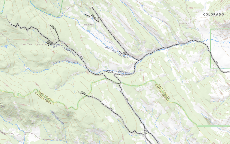
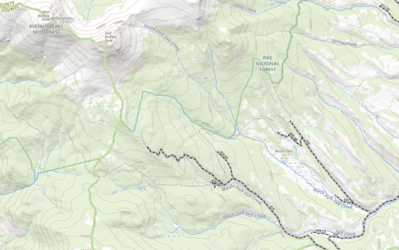
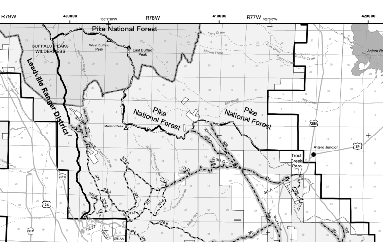
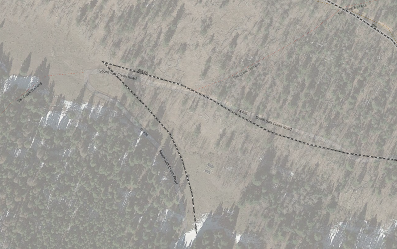
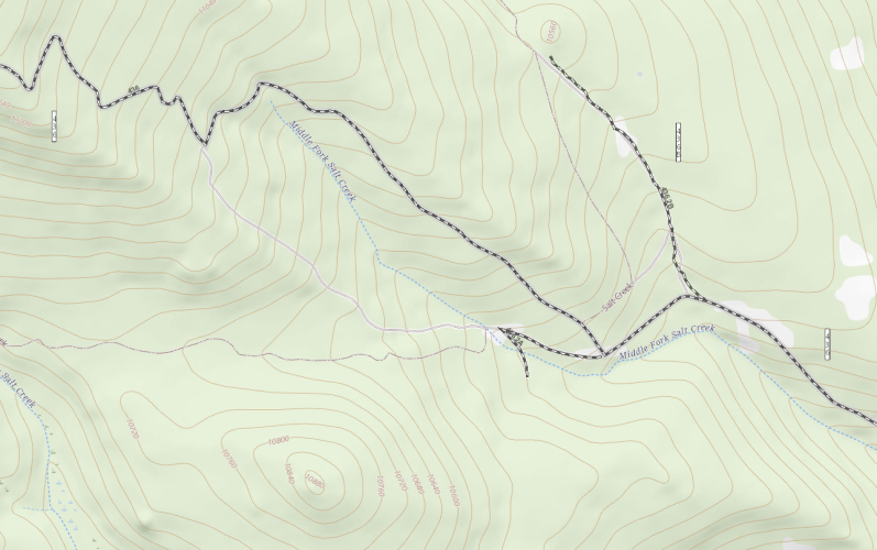
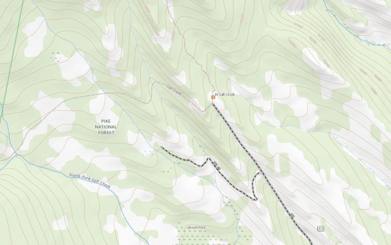
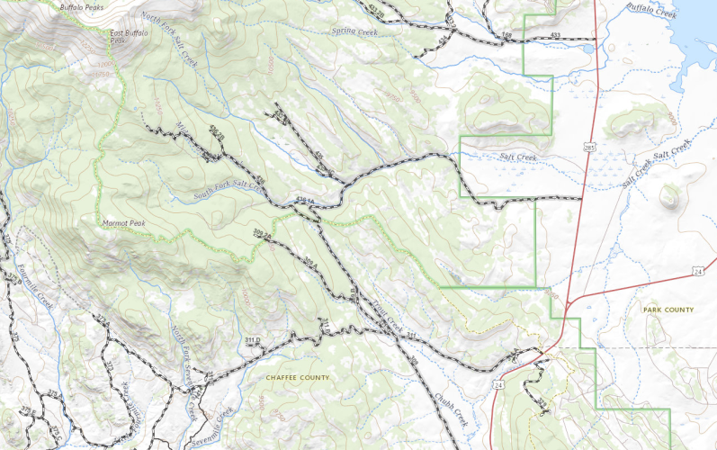
This is what I show from their public server.

salttroutfoursevenmile.png

middlenorthsouthsaltcreek.png

middlesouthbuffalopeaks.png

But the PDF MVUM doesn't show them. I wonder if you happened to be there on a day that someone had opened the gate and it's normally locked to vehicle traffic. Did it look like the route was closed to bikes or hiking, too?

Screen Shot 2023-07-10 at 2.08.31 PM.png

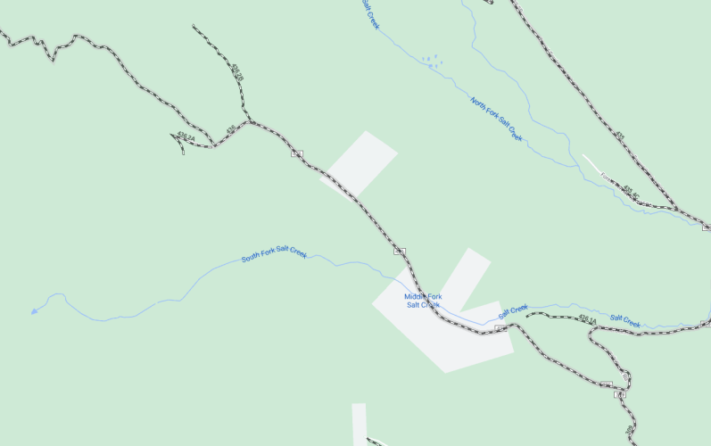
There looks to be a couple of inholdings right there which might have the access control. Ownership isn't clear to me, whether it's private or State Land Board or otherwise since Park County doesn't have parcel data available for distribution.

saltcreekinholding.png
 
Last edited:

nuclearlemon

Hard Core 4+
Joined
Aug 23, 2005
Messages
8,332
Location
windy wyo
Check with marcus trusty at core. he knows what's going on with all the trails out there
 

cbmontgo

Hard Core 4+
Joined
Dec 10, 2007
Messages
1,147
Location
Divide, Colorado
Definitely sounds USFS closed.

This is what I show from their public server.

View attachment 117567

View attachment 117566

View attachment 117569

But the PDF MVUM doesn't show them. I wonder if you happened to be there on a day that someone had opened the gate and it's normally locked to vehicle traffic. Did it look like the route was closed to bikes or hiking, too?

View attachment 117568

There looks to be a couple of inholdings right there which might have the access control. Ownership isn't clear to me, whether it's private or State Land Board or otherwise since Park County doesn't have parcel data available for distribution.

View attachment 117574
Thanks for posting these maps. So it was Road 436 which was closed, and the gate is where I made the red mark.

It didn’t appear to be closed to bikes or hiking, although it could have been.

IMG_3528.jpeg

On the Fourmile Recreation Area map, it shows this area as being in Pike National Forest.
IMG_3529.jpeg
 

DaveInDenver

Rising Sun Ham Guru
Joined
Jun 8, 2006
Messages
13,139
Location
Grand Junction
That actually seems close to what the historical topo shows. The gate is moved but as approximate locations go that's not *that* far off. It's a fairly significant difference in what it closed off, though.

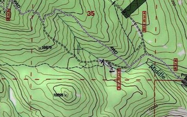
middlefork436ahistoricaltopo.png

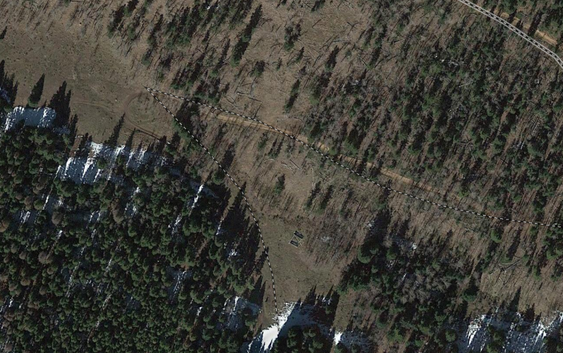
Obviously the intention back then was to prevent travel on 436.1A (no longer shown in MVUM) and that short spur is now numbered 436.2A. Wonder what's back there, maybe an old lumber camp or cabin?

fr436_2a_layered.png

fr436_2a_satellite.png

There's trail 618 (named Salt Creek in some views) is why I asked. The trailhead is the end of FS435 the next drainage east.

saltcreek618_natmap.png

saltcreek618_TH_natmap.png
 
Last edited:

DaveInDenver

Rising Sun Ham Guru
Joined
Jun 8, 2006
Messages
13,139
Location
Grand Junction
BTW, one of the reasons for the detailed analysis is I actually did know of this trail.
 

Attachments

  • saltcreek_618poorscan.PDF
    1 MB · Views: 84

cbmontgo

Hard Core 4+
Joined
Dec 10, 2007
Messages
1,147
Location
Divide, Colorado
That actually seems close to what the historical topo shows. The gate is moved but as approximate locations go that's not *that* far off. It's a fairly significant difference in what it closed off, though.

View attachment 117600

Obviously the intention back then was to prevent travel on 436.1A (no longer shown in MVUM) and that short spur is now numbered 436.2A. Wonder what's back there, maybe an old lumber camp or cabin?

View attachment 117605

View attachment 117606

There's trail 618 (named Salt Creek in some views) is why I asked. The trailhead is the end of FS435 the next drainage east.

View attachment 117602

View attachment 117603
So that gate on 436.1A is actually where the road changes to a hiking trail and it looks like it's been closed for a long time to motor vehicles.

There is cool old camp back there indeed, with several very old log cabins. Our plan on Sunday was to drive to the cabins again and then head north on that 4WD road, which is just past the newly closed gate. It appears to go to some really cool ponds near the treeline.
 

cbmontgo

Hard Core 4+
Joined
Dec 10, 2007
Messages
1,147
Location
Divide, Colorado
Here’s where the road is now a hiking trail:
IMG_3530.jpeg

This is the 4WD road we were gonna take on Sunday (closed gate is the red line on the right side of photo):
IMG_3530.jpeg
 

shellb

Hard Core 4+
Joined
Feb 6, 2013
Messages
690
Location
Erie CO
This is a fantastic discussion and usage of maps! Super cool and interesting.

I need to spend more time looking at maps in general.

@DaveInDenver how does one go about getting those maps you've pasted in? I've historically only used the MVUM that come in pdf, which don't look like the green maps you've posted.
 

DaveInDenver

Rising Sun Ham Guru
Joined
Jun 8, 2006
Messages
13,139
Location
Grand Junction
@DaveInDenver how does one go about getting those maps you've pasted in? I've historically only used the MVUM that come in pdf, which don't look like the green maps you've posted.
In a word: GIS

The longer answer here is it's not one thing you can just download, install and be up and running without some effort. I use QGIS personally. In an ideal world it would be ArcGIS but I don't have the budget.

But the GIS application is only a basic framework, all the effort is the basemap tile and feature servers and local GPX, Shapefiles or geo databases. In the case of this thread most of the basemaps are the USGS National Map topo or Google Road and Satellite maps with a combination of USFS MVUM local and online as well as other features (like county GIS information, ranger district and Wilderness boundaries) layered on top. The historical USGS quads usually come from Esri (ArcGIS) public servers or my Caltopo subscription.

It's an ongoing thing since REST servers are changing, data grows stale, layers require massaging to display right. Some of it can be done using Caltopo, OnX or Gaia directly but they are naturally limited in customization and that's why I originally taught myself rudimentary GIS. I wanted to be able to research USFS and BLM alternatives to give meaningful comments, to be able to see what they see unfiltered.
 

shellb

Hard Core 4+
Joined
Feb 6, 2013
Messages
690
Location
Erie CO
That is awesome, even though I have no idea what any of it means.

Something for me to research and learn!

Very appreciative of the reply, thank you!
 

DaveInDenver

Rising Sun Ham Guru
Joined
Jun 8, 2006
Messages
13,139
Location
Grand Junction
I found the textbook "GIS Fundamentals" by Bolstad useful as a one-stop rapidly get up to speed reference. Mine is a 5th edition and they're on a 7th it looks like, so I've been at this a while now.


But I also came to it with some professional experience in surveying and GPS and recreational orienteering and map reading. So it wasn't completely starting from zero. I'd call myself probably a solid intermediate in GIS. Certainly not ready-to-go professional but I think I could get around without too much hand holding.
 
Top