Exploring to hike and camp. Help on how to identify if it’s legal to.

Oneops

Locked
Joined
May 12, 2021
Messages
283
How or what do you use? I’ve used a couple apps and mostly on X along with the wells books for trails. I thought I read you could dl a hunting version of on x to show plots and ownership if not I’m pretty sure I can add it for more money. Outside of that I currently don’t have much of a plan.
Dropped pin
Wanted to camp at the end of this road or go further on the two track and explore.
 

wesintl

RS Moderator
Moderator
Joined
Aug 22, 2005
Messages
8,595
Location
in da house
private property you can see the houses. there is a small stretch before you get to that of blm. after the houses there is another private holding before you it's beaver creek state wildlife area and BLM. goes to skagway power plant ruins. mvum (motor vehicle use map) of that area would show public routes. Other than that you would have to go and see. I had onx 4x4 but never used it and i don't plan onx hunt works in a pinch to see private land
 
Last edited:

MountainGoat

Club Treasurer
Staff member
Cruise Moab Committee
Joined
Jul 4, 2008
Messages
3,075
Location
Evergreen, CO
Yeah, it is a private inholding in BLM land. Here is the Gaia Public Land overlay for it. The yellowish areas are BLM:

Public Land Map.jpg


The MVUM shows no legal motorized routes.
 

Oneops

Locked
Joined
May 12, 2021
Messages
283
If that is a county rd I should be able to drive through the private property on it to reach the blm or no? The state park property allows camping in and around the ruins would this area above that be different? Haven’t been to the ruins yet looks freaking cool!
 

Oneops

Locked
Joined
May 12, 2021
Messages
283
Thanks for looking btw!
 

MountainGoat

Club Treasurer
Staff member
Cruise Moab Committee
Joined
Jul 4, 2008
Messages
3,075
Location
Evergreen, CO
If that is a county rd I should be able to drive through the private property on it to reach the blm or no? The state park property allows camping in and around the ruins would this area above that be different? Haven’t been to the ruins yet looks freaking cool!
Theoretically yes. But the google map shows the county road ending before the BLM property line. It all depends on how it looks on the ground when you roll up on it.

I know that around here (Evergreen and Conifer) property owners have a bad habit of posting public thoroughfares with no trespassing signs to deter explorers. Often times these are on legal public roads that pass through private property before getting to public land access. This is where a Public Lands layer on your mapping app is super helpful.

You really need to be sure that you are still on the county road if you want to stay out of trouble. Have you checked the county assessor's website to see what the property boundary looks like? They are usually a pain in the butt to navigate, but it might give you a clue. :)
 

DaveInDenver

Rising Sun Ham Guru
Joined
Jun 8, 2006
Messages
13,114
Location
Grand Junction
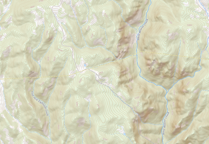
Teller County's GIS shows County Road 863 coming well short of what's mapped by the USGS by maybe a mile and doesn't give parcel owner information. The Fremont County GIS is even less helpful. I don't find publicly available GIS data via the Colorado GIS Coordination Office for either so there's only what's given on the county websites. Caltopo has parcel data. Looks like the county right of way or maintenance stops at the Strong Family property maybe?

There's routes in OpenStreetMap, which is likely the original source for other maps like Gaia or Garmin. I don't see any indication that the route has ever been verified in person for OSM. It was originally imported into the database from U.S. Census TIGER data about 14 years ago.

https://www.openstreetmap.org/way/17149776/history
https://www.openstreetmap.org/way/17047227/history

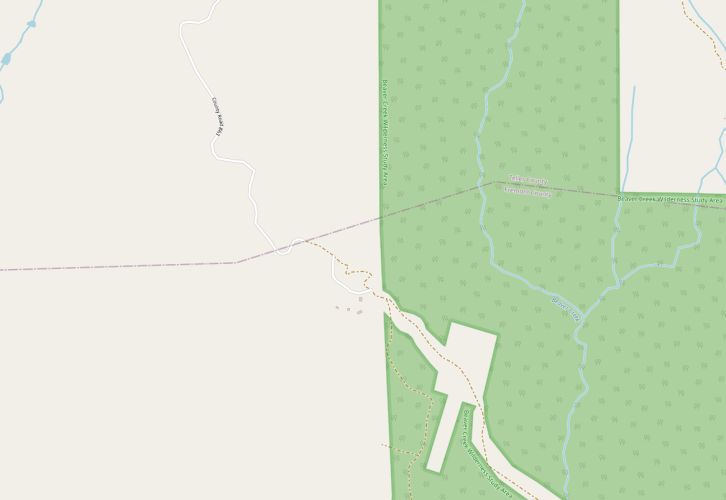
The USFS shows Beaver Creek State Wildlife Area that's adjacent along the creek up to Skagway Reservoir. Anyone fishing/hunting in the BCSWA seem to be backpacking either from Skagway or a significant hike in following the creek from the south, so getting to that little spur is exceptionally difficult using the CPW guidelines.

Hard to say there's anything indicating an obvious, established legal route all the way but also nothing that would necessarily say it's definitely illegal to try following historical topo maps (e.g. pre-NEPA grandfathered routes which the USGS would have used for the National Map) or anything that's still on the ground. Neither the USFS MVUM (which isn't surprising, it's not USFS land) nor the BLM GTLF show anything. The BLM has much less developed travel data and generally a route on BLM land is open unless clearly closed via Carsonite sign or indicated on maps.

Your actual coordinates are on private property, that would be illegal to camp upon. But if there's a way to get in you might be OK on BLM dispersed or with a hunting or fishing license on the SWA property.

The USGS 7.5' quads.
Bull Mountain:
https://pdf.quad.download.s3.amazonaws.com/38105f1.pdf
Phantom Canyon:
https://pdf.quad.download.s3.amazonaws.com/38105e1.pdf

But even with more current data (talking around Mesa, Garfield, Rio Blanco, Moffat) I've personally come up to well and truly locked gates and fences where none are indicated on maps, thus forced backtracking.

Putting tires on dirt and eyes on things could be useful, too. This sort of exploration, to me, is *the* real essence of 4x4 and the relative security of driving a Toyota means you'll likely make it there and back.

Happy travels!

Screen Shot 2022-05-28 at 5.58.50 PM.png
4L6CK.jpeg
 

Attachments

  • bcswa_inholding_USGS.png
    bcswa_inholding_USGS.png
    2.3 MB · Views: 92
  • bcswa_inholding_OSM.png
    bcswa_inholding_OSM.png
    143.4 KB · Views: 105
Last edited:

LARGEONE

Rising Sun Member
Joined
Jun 12, 2007
Messages
2,888
Location
Broomfield, CO
Theoretically yes. But the google map shows the county road ending before the BLM property line. It all depends on how it looks on the ground when you roll up on it.

I know that around here (Evergreen and Conifer) property owners have a bad habit of posting public thoroughfares with no trespassing signs to deter explorers. Often times these are on legal public roads that pass through private property before getting to public land access. This is where a Public Lands layer on your mapping app is super helpful.

You really need to be sure that you are still on the county road if you want to stay out of trouble. Have you checked the county assessor's website to see what the property boundary looks like? They are usually a pain in the butt to navigate, but it might give you a clue. :)
So, I can't comment about this exact location, but this is almost exactly the situation for my property outside of BV. As Dan initially stated, many of my neighbors have put official looking signs saying "No Forest Access", "Private Roads beyond this point", etc. The county road shows that it ends, but that is just because the county doesn't want to maintain the road. Technically the county easement goes all the way through my private property, but they don't maintain the road, so it is only shown as county road to the point where they maintain. My neighbor tried to put a gate across the road, (he maintains it with his tractor) and the county made him keep the gate open. So, while the road looks private and even has a gate (open), it is totally public easement through both of our properties.

I'm not saying this is the case on that property you are questioning, but you can look up the deed for that property (public information) and see if the deed describes an easement through the property. My deed states there is a public easment 20 ft wide along the old Latchaw mine road cutting through the property. I have to respect that...I can put up all the signs I want telling people it is private, but I cannot do a damn thing if someone challenges me on it. It is PUBLIC.
 

Inukshuk

Rising Sun Member
Joined
Aug 24, 2005
Messages
7,300
Location
Denver, CO
you can look up the deed for that property (public information) and see if the deed describes an easement through the property.
Keep in mind that this is not the definitive answer. Many times, I'd say more often than not, the current owner's deed will say nothing about easements crossing the property. Would be nice if it was that simple.

To the original Q: "Help on how to identify if it’s legal to" - sometimes its really hard to know. We once got chased off land in Wyoming where teh BLM map showed a road and an Oregon Trail historic marker. Guy was pissed at the BLM.
 

DaveInDenver

Rising Sun Ham Guru
Joined
Jun 8, 2006
Messages
13,114
Location
Grand Junction
Keep in mind that this is not the definitive answer. Many times, I'd say more often than not, the current owner's deed will say nothing about easements crossing the property. Would be nice if it was that simple.

To the original Q: "Help on how to identify if it’s legal to" - sometimes its really hard to know. We once got chased off land in Wyoming where teh BLM map showed a road and an Oregon Trail historic marker. Guy was pissed at the BLM.
"There’s what’s right, and there’s what’s right, and never the twain shall meet." -- H.I. McDunnough
 

AlpineAccess

Hard Core 4+
Joined
Nov 19, 2019
Messages
1,263
Location
Loveland
Is there anything punitive for someone knowingly marking public land private to deny use by other citizens?
 

DaveInDenver

Rising Sun Ham Guru
Joined
Jun 8, 2006
Messages
13,114
Location
Grand Junction
Is there anything punitive for someone knowingly marking public land private to deny use by other citizens?
The High Lonesome Ranch lost a suit with the FedGov and Garfield County over a gate they had placed which restricted access on a BLM road.


And the road is definitely a public way with a western terminus that you can use, so the locked gate coming from the southeast was a major PITA when it was still locked.

IMG_1589.png
 
Last edited:

AlpineAccess

Hard Core 4+
Joined
Nov 19, 2019
Messages
1,263
Location
Loveland
The High Lonesome Ranch lost a suit with the FedGov and Garfield County over a gate they had placed which restricted access on a BLM road.


And the road is definitely a public way with a western terminus that you can use, so the locked gate coming from the southeast was a major PITA when it was still locked.

View attachment 104553
I see them suing the county over the county making them unlock a gate and saying they are restricting public access to (depending on season) 50,000 to 90,000 Acres for Decade.

They weren't even required to remove it, nothing happened to them. Maybe we can all just block access to our streets and turn them into personal parking lots!

They claim the ranch is open to the public while charging $1200-2500 a day to come to the ranch?
 

DaveInDenver

Rising Sun Ham Guru
Joined
Jun 8, 2006
Messages
13,114
Location
Grand Junction
I see them suing the county over the county making them unlock a gate and saying they are restricting public access to (depending on season) 50,000 to 90,000 Acres for Decade.

They weren't even required to remove it, nothing happened to them. Maybe we can all just block access to our streets and turn them into personal parking lots!

They claim the ranch is open to the public while charging $1200-2500 a day to come to the ranch?
It's like a lot of these matters I suppose, complicated.

I don't see how they ever thought they could put the gate where they did, which wasn't on their property as near as I can tell. It was either on BLM land or actually in the easement. But there's certainly a significant mix of inholdings back there that they do own.

The actual mapped route of CR200 isn't nearly as well maintained and is clearly within the BLM property. I don't know if the ranch was grading the better section of road or the county, so there was confusion over what is the county road and what might be a private driveway.

And my assumption is that, yup, they wanted to prevent people who weren't staying at the ranch from getting in there easily to hunt and fish mainly. It was possible to get around it with a Land Cruiser or MTB or dirt bike anyway.

highlonesomegate.png
 
Last edited:
Top