Blue Notch Canyon, Memorial Day weekend, 2010.

bh4rnnr

Outlaw, Scoundrel, Miscreant
Joined
Aug 23, 2005
Messages
6,299
Location
Littleton
How hot is it going to be there that time of year?
That time of year is fairly pleasent. June started to get hot in Beef Basin.

How close is a marina? May want to make it a longer weekend and take the boat there. Is the road nice enough to drive a trailer down it? I guess we could park the trailer at the marina and drive/ride to the meeting spot.

We normally go with about 4-6 other people to Moab but this looks to pretty to pass up. We'll have to see what the wife thinks.

Closest Marina would be Hite Crossing. You could always park at hite and meet us via speed boat. Just don't run over my inner tube:eek::hill::cheers:.
 

Mendocino

RS Chapter Eternal
Gone But
Not Forgotten
Joined
Sep 27, 2005
Messages
2,466
Location
North Side
Is there a map showing the trail; pictures would also be good if they are available? Would we camp in one spot for the entire time?
 

bh4rnnr

Outlaw, Scoundrel, Miscreant
Joined
Aug 23, 2005
Messages
6,299
Location
Littleton
Is there a map showing the trail; pictures would also be good if they are available? Would we camp in one spot for the entire time?

Jeff, i'll work on this. Current plan is to camp in the same spot.
 

RockRunner

Hard Core 4+
Joined
Nov 19, 2006
Messages
4,431
Location
Roxborough
So how long of a trip would Hite Crossing be? If we do it we would take the Dodge with the camper on it and the boat. Sharon could drive the boat and I would take the truck depending on how much extra time it would add.

Can the Dodge make it??
 

Mendocino

RS Chapter Eternal
Gone But
Not Forgotten
Joined
Sep 27, 2005
Messages
2,466
Location
North Side
So how long of a trip would Hite Crossing be? If we do it we would take the Dodge with the camper on it and the boat. Sharon could drive the boat and I would take the truck depending on how much extra time it would add.

Can the Dodge make it??
Good question. Ideally I would take the crewcab and trailer the 40. It would be very convienant if the crew cab and trailer could make it to the camp spot. Btw-I did read that the lake is pretty cold in May and that wet suits are needed for skiing.
 

bh4rnnr

Outlaw, Scoundrel, Miscreant
Joined
Aug 23, 2005
Messages
6,299
Location
Littleton
So how long of a trip would Hite Crossing be? If we do it we would take the Dodge with the camper on it and the boat. Sharon could drive the boat and I would take the truck depending on how much extra time it would add.

Can the Dodge make it??

What about just taking the speedboat from Hite to camp? As others have stated, it's about 9 hours to the trail head from Denver.

Good question. Ideally I would take the crewcab and trailer the 40. It would be very convienant if the crew cab and trailer could make it to the camp spot. Btw-I did read that the lake is pretty cold in May and that wet suits are needed for skiing.


I'd be hesitant about bringing this kind of vehicle on the trail. I understand your thoughts, but as stated, this trail is a remote seldome used road. It may be fine and we could blast all the way to camp @ 60mph. Or it could be the complete opposite... I stay hesitant, only cause I have not been and give you a good answer. We can plan this trip a in and out, so you can get back to the tow vehicles.

From the trail head, it looks to be a good 15-20 miles to camp.

Jeff, here is a map I (again) borrowed from Expedition Utah. Also more pics.


:beer::beer:
 

Attachments

  • orig.jpg
    orig.jpg
    153.3 KB · Views: 390
  • BN1.jpg
    BN1.jpg
    111.6 KB · Views: 344
  • BN2.jpg
    BN2.jpg
    82.2 KB · Views: 349

Red_Chili

Hard Core 4+
Joined
Aug 24, 2005
Messages
8,335
Location
Littleton CO
I think the Dodge might have trouble.. :lmao:

Wow, what an awesome MOTORCYCLE trip too! Maybe Tramontana will spot this thread.

Looking forward to it.
 

RockRunner

Hard Core 4+
Joined
Nov 19, 2006
Messages
4,431
Location
Roxborough
I think the Dodge might have trouble.. :lmao:


Looking forward to it.

Hey it is locked and on 35"s :D Of course the full size camper on the back may cause a small problem in the tight areas :rolleyes: It will just take a little finesse driving and a heavy foot on the throttle if that doesn't work:D
 

Mendocino

RS Chapter Eternal
Gone But
Not Forgotten
Joined
Sep 27, 2005
Messages
2,466
Location
North Side
This NAXJA site has some good narrative on the area and the trail. It seems that there are a lot of the same pictures on Expedition Utah. Good stuff.:thumb:

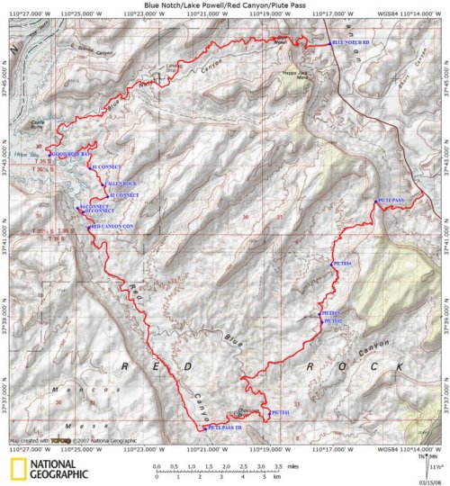
This overnight loop has the dual goals of taking you on some seldom driven mining roads while delivering you to a rare vehicle accessable primitive campsite on the shore of Lake Powell.

Blue Notch Pass is a rough dirt road drive from Hwy 95 that most of the people you see at the shore will have used to to get there. The adventure begins when you drive out through Red Canyon and over Piute Pass.

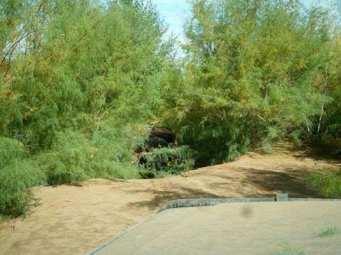
There was quite a bit of prospecting going on in the Red Canyon area before the creation of Lake Powell that left a number of old roads. The shrinking lake has uncovered enough of the lower part of Red Canyon that the route where it connected to Blue Notch Canyon has once again become accessable. This canyon filled in with sediment when the lake was full, then the tamarisk came along to form thickets in the soft, moist sand. Now that the lake has dropped 100+ feet, this sediment is getting washed away by the intermittent stream that floods Red Canyon whenever it rains. The tamarisk is doing what it was originally imported to do, namely stabilize the banks of the canyon. This has caused tall, vertical cutbanks to form. The challange is to find your way through the overgrowth of this invasive plant to the one point where there is no cutbank. The map, and more importantly, the track and waypoints in the .gpx file, will help you locate this point. There are several dead end spurs along the the main route, now it should be easier to determine which way not to go as most of them have been recently marked with "route closed" posts. You will find a set of pruners or a saw handy when you get into the tamarisk because it rapidly reclaims the trail. Be careful when you make it to Red Canyon proper- the water table is close to the surface here and it is easy to find quicksand, especially after a rainstorm. Do not use this route if thunderstorms threaten as it is flood prone.

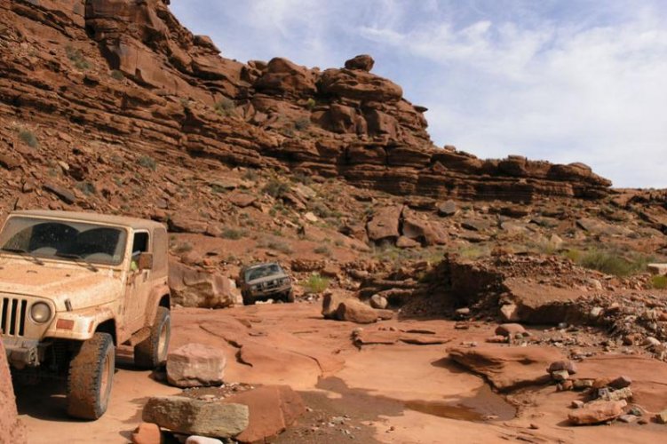
Driving upcanyon, in a little less than a mile you will climb above the high water mark to find a better defined Red Canyon Road, which will meander across the stream. After that the canyon will become broader and drier. In 9 miles or so, Piute Pass will come in from the left side of the canyon. This road is marked with a "Canyon Riders Trail" signpost and seems to be used primarily by ATVs, judging by the narrowness of the road in several places. It winds up and over some colorful clay hills that would not be fun when wet, then takes you for a short drive through Blue Canyon before climbing the 2000 feet up to Piute Pass. This whole area is crisscrossed with prospecting roads and a longer loop can be made, if you desire.

In late 2007 Glen Canyon National Recreation Area began the process of revising their OHV travel plan. I submitted the point connecting these two trails below lake level on roads that predated the dam and lake to be included in that plan. There will be more opportunities to comment on this plan in the months to come, hopefully it will be added to the map!

orig.gif


orig.jpg


orig.jpg


orig.jpg


orig.jpg


orig.jpg


:cheers::cheers:
 

bh4rnnr

Outlaw, Scoundrel, Miscreant
Joined
Aug 23, 2005
Messages
6,299
Location
Littleton
This NAXJA site has some good narrative on the area and the trail. It seems that there are a lot of the same pictures on Expedition Utah. Good stuff.:thumb:


orig.gif


orig.jpg


orig.jpg


orig.jpg


orig.jpg


orig.jpg


:cheers::cheers:


That's the same guy posting on both forums. He has some great trip reports.
 

rover67

Rising Sun Member
Joined
Nov 1, 2007
Messages
9,581
Location
Boulder, Co
Hey Perry, I think I'd like to do this trip. Need to make sure we don't have something else planned first though. I tend to forget about things sometimes.
 

Convert

Hard Core 4+
Joined
Aug 25, 2005
Messages
1,412
Perry
Looks like Trudy and I are in and were hoping BVB will be also:thumb:
 

bh4rnnr

Outlaw, Scoundrel, Miscreant
Joined
Aug 23, 2005
Messages
6,299
Location
Littleton

jacdaw

Hard Core 4+
Joined
Jan 29, 2009
Messages
1,229
Location
Lafayette
This is looking interesting. Perry, is the trail portion out and back, or would it be a loop? I may want to trailer the 40 instead of ~18 hours of highway driving.

Also, is anyone interested in coming back on Tuesday? I would not mind missing the traffic but would like to caravan, especially if I'm driving the 40.
Jeff, I will not have a locker by then, so if you promise to tug me through the rough patch, I will stay and caravan with you on Tuesday.:D
 

Mendocino

RS Chapter Eternal
Gone But
Not Forgotten
Joined
Sep 27, 2005
Messages
2,466
Location
North Side
Jeff, I will not have a locker by then, so if you promise to tug me through the rough patch, I will stay and caravan with you on Tuesday.:D
Have strap will tug.:)

I still have not sorted out my trailer deficit though.:rolleyes:
 

jacdaw

Hard Core 4+
Joined
Jan 29, 2009
Messages
1,229
Location
Lafayette
Have strap will tug.:)

I still have not sorted out my trailer deficit though.:rolleyes:
If you drive the 40, rest assured you will be able to drive faster than my hilux.:( Or at least you won't be eating my dust on I-70.
 

pramjockey

Wincher
Joined
Sep 3, 2009
Messages
80
Location
Denver, CO
This sounds interesting. Something my basically-stock FJC could make it through?

The trick would be getting Tuesday off - I have to save up PTO for a kayak trip in July. If I could leave Fri and make it back Monday night, I'm thinkin that I'd like to join.
 
Joined
Sep 15, 2009
Messages
13
Location
Morrison
Sounds like a great trip!

I put in for the time off, so as long as it gets approved i'm in!:cheers:
 

Red_Chili

Hard Core 4+
Joined
Aug 24, 2005
Messages
8,335
Location
Littleton CO
Pets are allowed except:
-Along the San Juan River from Clay Hills Crossing upstream to the Glen Canyon NRA boundary as designated by required permit available through the Bureau of Land Management.

-Dogs and other companion animals are prohibited from entering Coyote Gulch within the boundaries of GCNRA. (This prohibition does not apply to guide dogs accompanying visual impaired persons or to hearing ear dogs accompanying hearing impaired persons.) This prohibition includes all dogs or other pet animals used to carry or transport recreational equipment or food.

Where is that exactly?

[edit] Ah, I think I see it. The San Juan River is S and SE of where we will be. Still looking for Coyote Gulch.
[edit2] Ah, found that too. Way west of where we will be. Dogs are good.
 
Back
Top