• RS MAY CLUB MEETING
    Hi Guest: Our monthly RS meeting on Wed. May 1st will be held at the Rooney Sports Complex. Details and directions are here. Early start time: 7:00 pm. to take advantage of daylight. We'll be talking ColoYota Expo and Cruise Moab.
    If you are eligible for club membership, please fill out an application in advance of the meeting and bring it with you.

Argentine lower road

rushthezeppelin

Rising Sun Member
Joined
Oct 14, 2022
Messages
1,157
Did this get closed because of the washout? I noticed things were rearranged on trails off-road and the lower road no longer has a listing.
 

mcgaskins

Rising Sun Member
Joined
Sep 14, 2012
Messages
1,898
Location
Denver, CO
If you’re referring to the half mile or stretch near the beginning of the trail, the lower section doesn’t exist any more. It’s completely turned into a boulder strewn stream and basically impassable. I was just there today and was shocked by how much it changed in the last couple years. I had to keep looking the map to be sure I was where I thought I was.
 

rushthezeppelin

Rising Sun Member
Joined
Oct 14, 2022
Messages
1,157
If you’re referring to the half mile or stretch near the beginning of the trail, the lower section doesn’t exist any more. It’s completely turned into a boulder strewn stream and basically impassable. I was just there today and was shocked by how much it changed in the last couple years. I had to keep looking the map to be sure I was where I thought I was.
Talking about the one section that has water running on the road most of the time and then has the deep creek crossing. The washout we saw early in the summer on a club run was right before the deep crossing.
 

Cruisertrash

Rising Sun Member
Joined
Aug 18, 2020
Messages
2,010
Location
Denver
If you’re referring to the half mile or stretch near the beginning of the trail, the lower section doesn’t exist any more. It’s completely turned into a boulder strewn stream and basically impassable. I was just there today and was shocked by how much it changed in the last couple years. I had to keep looking the map to be sure I was where I thought I was.
I think @rushthezeppelin is talking about the part we did on the clean up run earlier this year. It’s a couple miles in, the trail is IN the creek for a stretch, and then coming up out of the creek the trail is washed out, so there’s a bypass up and around to get back up to dry land.

Trail in the creek. Waiting in line for people to navigate the washed out section.
BBD88830-F320-49B4-B08C-6914F901EF6D.jpeg


Here’s @DomOfTheDead going directly up the washout. I think he was the only one that tried that.
73458C99-FA3B-4374-BBD1-1686F8270C66.jpeg


Here’s the 70 fire truck (don’t know his forum handle) stuck trying to get up the bypass, which went to the right compared with Dom’s line. In other words from the point of view of this photo Dom went straight ahead, away from the camera.
C03BAE39-1423-4629-B219-EE907E1BA132.jpeg


And somebody else, I forget who, having just come up the bypass. The creek is to the left, out of the frame, but the point of view is the same.
A9722FCB-604F-4F9A-84C9-CAC27272D548.jpeg


Reverse view, 180 degrees from the other photos, of me coming up the bypass. Photo by @Yarn Cruiser. She was probably standing near where the guy in the red shirt is in the photo above. You can see folks on the in-creek part of the trail waiting in line in the background.
A9D42EC0-E989-4D24-B8C8-2968595A0F46.jpeg


Hopefully the photos give perspective to the issue. Honestly, it was difficult to tell where the trail even was for a 100’ stretch right there. I think most of us later learned that the route we took was a bypass, and that the washed out route Dom took was formerly the real trail route.
 

jps8460

Cruise Moab Committee
Joined
Feb 15, 2013
Messages
2,926
Location
Broomfield
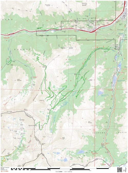
Wait, this is closed? Are we sure it’s closed?
 

rushthezeppelin

Rising Sun Member
Joined
Oct 14, 2022
Messages
1,157
Wait, this is closed? Are we sure it’s closed?
That's what I'm trying to find out. That lower road is not on Trails Offroad now. I don't know if they took it off in hopes of keeping more people from mobbing it and possibly hastening a closure or if it is in fact closed now.
 

mcgaskins

Rising Sun Member
Joined
Sep 14, 2012
Messages
1,898
Location
Denver, CO
This is the section I was referring to in between the points I marked on my Gaia map with the red circles. I hadn’t been up this section in a couple years and was surprised to see how much it’s changed - although this may be old news here.

IMG_6584.png


Yesterday I took 248.1B and didn’t encounter any issues, but I exited onto 248.1K to 248.2A to 248.2C to the dead end that used to connect down to the Waldorf Mine. As a side note, there is a guy named Jeff building a cool little cabin near the dead end on 248.2C who drives a red Tacoma. He was very friendly and I told him about Rising Sun and our involvement with helping the forest service keep the trail clean and open. I’d like to invite him on the official clean up run next year.

The only closure I encountered yesterday was the place marked on my map above, but it sounds like the section being discussed is 248.1 beyond the turnoff to 248.1K. If someone can confirm that would be helpful.
 

DaveInDenver

Rising Sun Ham Guru
Joined
Jun 8, 2006
Messages
13,082
Location
Grand Junction
Last edited:

Yarn Cruiser

Rising Sun Member
Joined
Jun 15, 2020
Messages
365
Per the Forest Service this section is not closed just rough. They are working with an engineer to do trail mitigation and would like help. They don't have a date yet but should be September. My source, talking with them now. At an event where they are at with Stay The Trail.
 
Top